
Topografische kaart Albert County
Interactieve kaart
Klik op de kaart om de hoogte weer te geven.
Over deze kaart
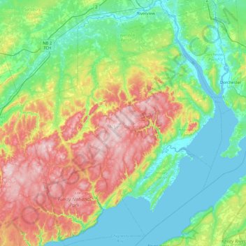
Naam: Topografische kaart Albert County, hoogte, reliëf.
Locatie: Albert County, New Brunswick, Canada (45.51329 -65.22357 46.09187 -64.54696)
Gemiddelde hoogte: 126 m
Minimale hoogte: -1 m
Maximale hoogte: 420 m
Andere topografische kaarten
Klik op een kaart om zijn topografie, zijn hoogte en zijn reliëf te bekijken.
The Glades
Canada > New Brunswick > Salisbury Parish
The Glades, Salisbury Parish, Westmorland County, New Brunswick, Canada
Gemiddelde hoogte: 72 m
Saint Quentin Parish
Saint Quentin Parish, Restigouche County, New Brunswick, E8A 1H5, Canada
Gemiddelde hoogte: 341 m
Clarendon Parish
Clarendon Parish, Charlotte County, New Brunswick, Canada
Gemiddelde hoogte: 160 m
Fredericton
Canada > New Brunswick > Kingsclear Parish > Island View
Fredericton, Island View, Kingsclear Parish, York County, New Brunswick, Canada
Gemiddelde hoogte: 70 m
Fredericton
Canada > New Brunswick > Fredericton
Fredericton, York County, New Brunswick, Canada
Gemiddelde hoogte: 68 m
Clarendon Parish
Clarendon Parish, Charlotte County, New Brunswick, Canada
Gemiddelde hoogte: 160 m
Moncton
Canada > New Brunswick > Moncton
Moncton, Moncton Parish, Westmorland County, New Brunswick, Canada
Gemiddelde hoogte: 52 m
Fundy National Park of Canada
Fundy National Park of Canada, 114, Albert County, New Brunswick, E4H 1N5, Canada
Gemiddelde hoogte: 230 m
Northumberland County
Northumberland County, New Brunswick, Canada
Gemiddelde hoogte: 177 m