
Topografische kaart Tamalpais-Homestead Valley
Interactieve kaart
Klik op de kaart om de hoogte weer te geven.
Over deze kaart
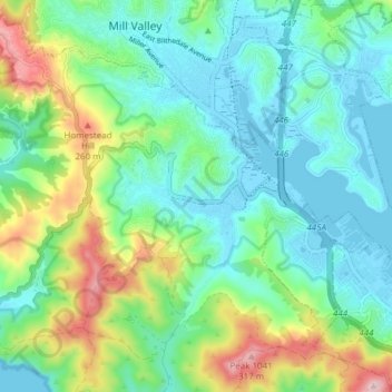
Naam: Topografische kaart Tamalpais-Homestead Valley, hoogte, reliëf.
Gemiddelde hoogte: 92 m
Minimale hoogte: -4 m
Maximale hoogte: 338 m
Andere topografische kaarten
Klik op een kaart om zijn topografie, zijn hoogte en zijn reliëf te bekijken.
Strawberry
United States > California > Marin County > Mill Valley
Strawberry, Mill Valley, Marin County, CAL Fire Northern Region, California, United States
Gemiddelde hoogte: 20 m
Alto
United States > California > Marin County > Mill Valley
Alto, Mill Valley, Marin County, CAL Fire Northern Region, California, 94941, United States
Gemiddelde hoogte: 53 m