
Topografische kaart Park View
Interactieve kaart
Klik op de kaart om de hoogte weer te geven.
Over deze kaart
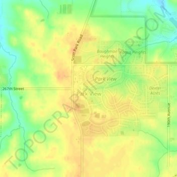
Naam: Topografische kaart Park View, hoogte, reliëf.
Locatie: Park View, Scott County, Iowa, United States (41.68768 -90.54906 41.70229 -90.52940)
Gemiddelde hoogte: 235 m
Minimale hoogte: 214 m
Maximale hoogte: 247 m
Andere topografische kaarten
Klik op een kaart om zijn topografie, zijn hoogte en zijn reliëf te bekijken.
Davenport
United States > Iowa > Scott County
Davenport, Scott County, Iowa, United States
Gemiddelde hoogte: 205 m
Buffalo
United States > Iowa > Scott County
Buffalo, Buffalo Township, Scott County, Iowa, 52728, United States
Gemiddelde hoogte: 205 m
Sheridan Township
United States > Iowa > Scott County
Sheridan Township, Scott County, Iowa, 52748, United States
Gemiddelde hoogte: 231 m
Bettendorf
United States > Iowa > Scott County > Pleasant Valley Township
Bettendorf, Pleasant Valley Township, Scott County, Iowa, 52722, United States
Gemiddelde hoogte: 207 m
Pleasant Valley Township
United States > Iowa > Scott County
Pleasant Valley Township, Scott County, Iowa, United States
Gemiddelde hoogte: 198 m
Le Claire
United States > Iowa > Scott County
Le Claire, Le Claire Township, Scott County, Iowa, United States
Gemiddelde hoogte: 200 m
Walcott
United States > Iowa > Scott County > Walcott
Walcott, Blue Grass Township, Scott County, Iowa, United States
Gemiddelde hoogte: 227 m
Eldridge
United States > Iowa > Scott County
Eldridge, Sheridan Township, Scott County, Iowa, 52748, United States
Gemiddelde hoogte: 234 m
Davenport
United States > Iowa > Scott County > Davenport
Davenport, Scott County, Iowa, 52801, United States
Gemiddelde hoogte: 212 m
Blue Grass
United States > Iowa > Scott County
Blue Grass, Blue Grass Township, Scott County, Iowa, United States
Gemiddelde hoogte: 239 m
Long Grove
United States > Iowa > Scott County
Long Grove, Scott County, Iowa, United States
Gemiddelde hoogte: 235 m