
Topografische kaart Marshall Forest
Interactieve kaart
Klik op de kaart om de hoogte weer te geven.
Over deze kaart
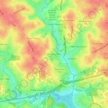
Naam: Topografische kaart Marshall Forest, hoogte, reliëf.
Gemiddelde hoogte: 278 m
Minimale hoogte: 241 m
Maximale hoogte: 309 m
Andere topografische kaarten
Klik op een kaart om zijn topografie, zijn hoogte en zijn reliëf te bekijken.
Kendall Green
United States > South Carolina > Greenville County > Greenville
Kendall Green, Greenville, Greenville County, South Carolina, 29614, United States
Gemiddelde hoogte: 298 m
Alta Vista
United States > South Carolina > Greenville County > Greenville
Alta Vista, Greenville, Greenville County, South Carolina, 29601, United States
Gemiddelde hoogte: 286 m
The Vintage Apartment Homes
United States > South Carolina > Greenville County > Greenville
The Vintage Apartment Homes, Greenville, Greenville County, South Carolina, 29614, United States
Gemiddelde hoogte: 305 m
Mountain View Homes
United States > South Carolina > Greenville County > Greenville
Mountain View Homes, Greenville, Greenville County, South Carolina, 29602, United States
Gemiddelde hoogte: 299 m
Boyce Lawn
United States > South Carolina > Greenville County > Greenville
Boyce Lawn, Greenville, Greenville County, South Carolina, 29601, United States
Gemiddelde hoogte: 290 m