
Doe een donatie
Rust jezelf uit voor je volgende avontuur:
Als Amazon-partner verdient deze site een commissie op in aanmerking komende aankopen, zonder extra kosten voor jou.
Topografische kaart Manti
Klik op de kaart om de hoogte weer te geven.
Doe een donatie
Rust jezelf uit voor je volgende avontuur:
Als Amazon-partner verdient deze site een commissie op in aanmerking komende aankopen, zonder extra kosten voor jou.
Manti
Manti has a humid continental climate (Köppen Dfb) with warm summers and cold winters, receiving on average barely enough rainfall to avoid a semi-arid classification (BSk). Its high elevation means that the climate is cooler than other populated areas of Utah, especially during summer. Summers highs average in the mid-80s°F, with winter highs in the mid-30s°F. Winter lows, however, dip to around 15–20 °F. Pacific storms move through the region from October through May and spring is the wettest season. However, summer, which is the driest season, primarily relies on precipitation from scattered diurnal thunderstorm activity and the Gulf of California monsoon. Winter and spring see frequent snowfall. Precipitation averages 12.70 inches and snowfall 52.2 inches. The record high temperature is 110 °F (43 °C), set on August 6, 1895, while the record low is −27 °F (−33 °C), set on January 22, 1937.
Doe een donatie
Rust jezelf uit voor je volgende avontuur:
Als Amazon-partner verdient deze site een commissie op in aanmerking komende aankopen, zonder extra kosten voor jou.
Over deze kaart
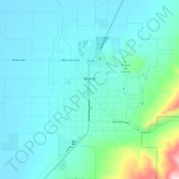
Naam: Topografische kaart Manti, hoogte, reliëf.
Locatie: Manti, Sanpete County, Utah, 84642, United States (39.24447 -111.65052 39.28690 -111.61145)
Gemiddelde hoogte: 1.743 m
Minimale hoogte: 1.665 m
Maximale hoogte: 2.144 m
Doe een donatie
Rust jezelf uit voor je volgende avontuur:
Als Amazon-partner verdient deze site een commissie op in aanmerking komende aankopen, zonder extra kosten voor jou.
Andere topografische kaarten
Klik op een kaart om zijn topografie, zijn hoogte en zijn reliëf te bekijken.