
Topografische kaart Orbey
Interactieve kaart
Klik op de kaart om de hoogte weer te geven.
Over deze kaart
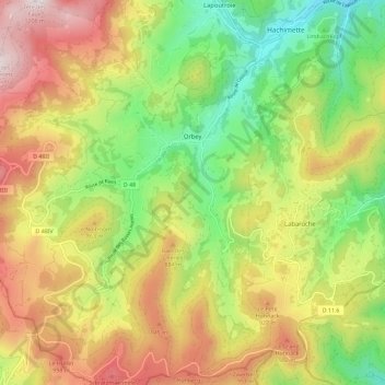
Naam: Topografische kaart Orbey, hoogte, reliëf.
Gemiddelde hoogte: 730 m
Minimale hoogte: 333 m
Maximale hoogte: 1.204 m
La commune d'Orbey fait partie du canton de Lapoutroie et de l'arrondissement de Colmar-Ribeauvillé et occupe la haute vallée de la Weiss, incluant les lacs Blanc et Noir. Elle s'adosse au massif des Vosges, dominée par les sommets du Linge, du Gazon du Faing et de la Tête des Faux. L’altitude du bourg est de 550 mètres. Orbey comprend de nombreux hameaux et des fermes éparpillées sur les versants de la montagne. ces dernières étant transformées en grande partie en maisons de vacances ou de weekend. La population est de langue française, de tradition welche.
Andere topografische kaarten
Klik op een kaart om zijn topografie, zijn hoogte en zijn reliëf te bekijken.
Masevaux-Niederbruck
France > Grand Est > Haut-Rhin
Masevaux-Niederbruck, Thann-Guebwiller, Haut-Rhin, Grand Est, France métropolitaine, 68290, France
Gemiddelde hoogte: 577 m
Hagenthal-le-Bas
France > Grand Est > Haut-Rhin
Hagenthal-le-Bas, Mulhouse, Haut-Rhin, Grand Est, France métropolitaine, 68220, France
Gemiddelde hoogte: 395 m
Ottmarsheim
France > Grand Est > Haut-Rhin
Ottmarsheim, Mulhouse, Haut-Rhin, Grand Est, France métropolitaine, 68490, France
Gemiddelde hoogte: 224 m
Ampfersbach
France > Grand Est > Haut-Rhin > Stosswihr
Ampfersbach, Stosswihr, Colmar-Ribeauvillé, Haut-Rhin, Grand Est, France métropolitaine, 68140, France
Gemiddelde hoogte: 634 m
Steinbrunn-le-Haut
France > Grand Est > Haut-Rhin
Steinbrunn-le-Haut, Mulhouse, Haut-Rhin, Grand Est, France métropolitaine, 68440, France
Gemiddelde hoogte: 320 m
Volgelsheim
France > Grand Est > Haut-Rhin
Volgelsheim, Colmar-Ribeauvillé, Haut-Rhin, Grand Est, France métropolitaine, 68600, France
Gemiddelde hoogte: 193 m
Sainte-Marie-aux-Mines
France > Grand Est > Haut-Rhin > Sainte-Marie-aux-Mines
Sainte-Marie-aux-Mines, Colmar-Ribeauvillé, Haut-Rhin, Grand Est, France métropolitaine, 68160, France
Gemiddelde hoogte: 713 m
Lapoutroie
France > Grand Est > Haut-Rhin > Lapoutroie
Lapoutroie, Colmar-Ribeauvillé, Haut-Rhin, Grand Est, France métropolitaine, 68650, France
Gemiddelde hoogte: 698 m
Vosges
France > Grand Est > Haut-Rhin > Goldbach-Altenbach
Vosges, Goldbach-Altenbach, Thann-Guebwiller, Haut-Rhin, Grand Est, France métropolitaine, 68760, France
Gemiddelde hoogte: 864 m
Wasserbourg
France > Grand Est > Haut-Rhin > Wasserbourg
Wasserbourg, Colmar-Ribeauvillé, Haut-Rhin, Grand Est, France métropolitaine, 68230, France
Gemiddelde hoogte: 729 m
Katzenthal
France > Grand Est > Haut-Rhin > Katzenthal
Katzenthal, Colmar-Ribeauvillé, Haut-Rhin, Grand Est, France métropolitaine, 68230, France
Gemiddelde hoogte: 293 m
Eschbach-au-Val
France > Grand Est > Haut-Rhin > Eschbach-au-Val
Eschbach-au-Val, Colmar-Ribeauvillé, Haut-Rhin, Grand Est, France métropolitaine, 68140, France
Gemiddelde hoogte: 630 m
Storckensohn
France > Grand Est > Haut-Rhin > Storckensohn
Storckensohn, Thann-Guebwiller, Haut-Rhin, Grand Est, France métropolitaine, 68470, France
Gemiddelde hoogte: 675 m
Sondernach
France > Grand Est > Haut-Rhin > Sondernach
Sondernach, Colmar-Ribeauvillé, Haut-Rhin, Grand Est, France métropolitaine, 68380, France
Gemiddelde hoogte: 931 m
Masevaux
France > Grand Est > Haut-Rhin > Masevaux-Niederbruck
Masevaux, Masevaux-Niederbruck, Thann-Guebwiller, Haut-Rhin, Grand Est, France métropolitaine, 68290, France
Gemiddelde hoogte: 577 m
Ribeauvillé
France > Grand Est > Haut-Rhin > Ribeauvillé
Ribeauvillé, Colmar-Ribeauvillé, Haut-Rhin, Grand Est, France métropolitaine, 68150, France
Gemiddelde hoogte: 395 m
Husseren-les-Châteaux
France > Grand Est > Haut-Rhin > Husseren-les-Châteaux
Husseren-les-Châteaux, Colmar-Ribeauvillé, Haut-Rhin, Grand Est, France métropolitaine, 68420, France
Gemiddelde hoogte: 398 m
Kaysersberg
France > Grand Est > Haut-Rhin > Kaysersberg-Vignoble
Kaysersberg, Kaysersberg-Vignoble, Colmar-Ribeauvillé, Haut-Rhin, Grand Est, France métropolitaine, 68240, France
Gemiddelde hoogte: 523 m
Niedermorschwihr
France > Grand Est > Haut-Rhin
Niedermorschwihr, Colmar-Ribeauvillé, Haut-Rhin, Grand Est, France métropolitaine, 68230, France
Gemiddelde hoogte: 339 m