
Topografische kaart Hampstead
Klik op de kaart om de hoogte weer te geven.
Over deze kaart
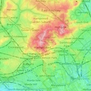
Naam: Topografische kaart Hampstead, hoogte, reliëf.
Locatie: Hampstead, Greater London, England, NW3 1QG, United Kingdom (51.51653 -0.21830 51.59653 -0.13830)
Gemiddelde hoogte: 57 m
Minimale hoogte: 9 m
Maximale hoogte: 136 m
Andere topografische kaarten
Klik op een kaart om zijn topografie, zijn hoogte en zijn reliëf te bekijken.
London Borough of Richmond upon Thames
United Kingdom > England > Greater London
Gemiddelde hoogte: 18 m
Norwood Grove
United Kingdom > England > Greater London
After Anderson died, ownership passed to the Nettlefold family and subsequently to Frederick Nettlefold the brother of Joseph Nettlefold and a member of the family that founded the Nettlefolds Ltd. engineering firm which later became GKN. Nettlefold is commemorated, as a result of his charitable works, by a…
Gemiddelde hoogte: 58 m
Pymmes Brook
United Kingdom > England > Greater London
Prior to the Anglian glaciation, a "proto-Mole-Wey" river was flowing northwards from the Weald and North Downs, through the "Finchley depression" and Palmers Green, to join the proto-Thames somewhere around Hoddesdon, at what is today an altitude of around 60 metres. It was this river which, during the course…
Gemiddelde hoogte: 41 m