
Doe een donatie
Rust jezelf uit voor je volgende avontuur:
Als Amazon-partner verdient deze site een commissie op in aanmerking komende aankopen, zonder extra kosten voor jou.
Topografische kaart Strawberry Mansion
Klik op de kaart om de hoogte weer te geven.
Doe een donatie
Rust jezelf uit voor je volgende avontuur:
Als Amazon-partner verdient deze site een commissie op in aanmerking komende aankopen, zonder extra kosten voor jou.
Over deze kaart
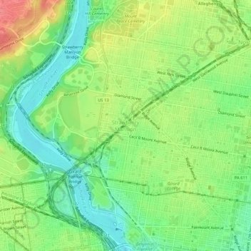
Naam: Topografische kaart Strawberry Mansion, hoogte, reliëf.
Gemiddelde hoogte: 31 m
Minimale hoogte: 1 m
Maximale hoogte: 74 m
Doe een donatie
Rust jezelf uit voor je volgende avontuur:
Als Amazon-partner verdient deze site een commissie op in aanmerking komende aankopen, zonder extra kosten voor jou.
Andere topografische kaarten
Klik op een kaart om zijn topografie, zijn hoogte en zijn reliëf te bekijken.
Pastorius Park
United States > Pennsylvania > Philadelphia County > Philadelphia
Gemiddelde hoogte: 108 m
Roxborough
United States > Pennsylvania > Philadelphia County > Philadelphia
Since the 1950s, most of Philadelphia's major television and FM radio stations have located their transmission towers in Roxborough because of its hilly terrain and high elevation. The tallest of these towers, the American Tower, stands approximately 1,250 feet (381m) tall. Public television station "MiND",…
Gemiddelde hoogte: 63 m
East Falls
United States > Pennsylvania > Philadelphia County > Philadelphia
East Falls takes its name from its location on the east side of the Schuylkill Falls along the Schuylkill River at the original line of waterfalls known as the 'Falls of the Schuylkill' where the river descends from the elevation of the Pennsylvania piedmont to the coastal plain occupied by the main part of…
Gemiddelde hoogte: 54 m
East Passyunk Community Recreation Center
United States > Pennsylvania > Philadelphia County > Philadelphia
Gemiddelde hoogte: 9 m
Doe een donatie
Rust jezelf uit voor je volgende avontuur:
Als Amazon-partner verdient deze site een commissie op in aanmerking komende aankopen, zonder extra kosten voor jou.
Wissahickon Valley Park
United States > Pennsylvania > Philadelphia County > Philadelphia
Gemiddelde hoogte: 77 m
Bartram's Garden
United States > Pennsylvania > Philadelphia County > Philadelphia
Gemiddelde hoogte: 13 m
Chestnut Hill
United States > Pennsylvania > Philadelphia County > Philadelphia
The village of Chestnut Hill was part of the German Township laid out by Francis Daniel Pastorius and came to include the settlements originally known as Sommerhausen and Crefeld, as well as part of Cresheim. It served as a gateway between Philadelphia and the nearby farmlands. During the American…
Gemiddelde hoogte: 97 m