
Topografische kaart Tengchong
Interactieve kaart
Klik op de kaart om de hoogte weer te geven.
Tengchong
Situated at the southwestern end of the (transversely faulted) Hengduan Mountains, Tengchong topographically assumes the form of a horseshoe with the opening facing the south. The easternmost sources of the Irrawaddy River issue from the high mountains at the summit of Mount Danaozi of Gaoligong Mountain, 3,780.2 m (12,402 ft) above sea level and the lowest point, 930 m (3,050 ft) above sea level, is in the Suqingjiang valley. The elevation of the city seat is 1,640 m (5,380 ft).
Over deze kaart
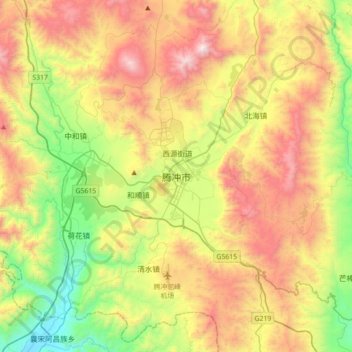
Naam: Topografische kaart Tengchong, hoogte, reliëf.
Locatie: Tengchong, Baoshan, Yunnan, 679100, China (24.86840 98.33368 25.18840 98.65368)
Gemiddelde hoogte: 1.770 m
Minimale hoogte: 1.059 m
Maximale hoogte: 2.715 m