
Doe een donatie
Rust jezelf uit voor je volgende avontuur:
Als Amazon-partner verdient deze site een commissie op in aanmerking komende aankopen, zonder extra kosten voor jou.
Topografische kaart Anahim Lake
Klik op de kaart om de hoogte weer te geven.
Doe een donatie
Rust jezelf uit voor je volgende avontuur:
Als Amazon-partner verdient deze site een commissie op in aanmerking komende aankopen, zonder extra kosten voor jou.
Over deze kaart
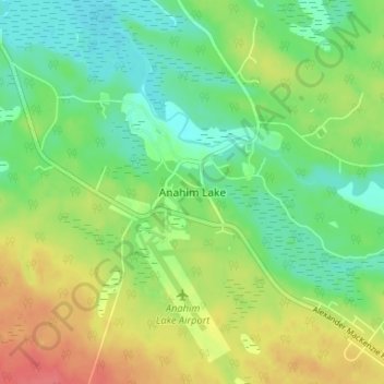
Naam: Topografische kaart Anahim Lake, hoogte, reliëf.
Gemiddelde hoogte: 1.101 m
Minimale hoogte: 1.078 m
Maximale hoogte: 1.134 m
Doe een donatie
Rust jezelf uit voor je volgende avontuur:
Als Amazon-partner verdient deze site een commissie op in aanmerking komende aankopen, zonder extra kosten voor jou.
Andere topografische kaarten
Klik op een kaart om zijn topografie, zijn hoogte en zijn reliëf te bekijken.
Kondor Lake
Canada > British Columbia > Cariboo Regional District > Area J (West Chilcotin)
Gemiddelde hoogte: 1.718 m
Nimpo Lake
Canada > British Columbia > Cariboo Regional District > Area J (West Chilcotin)
Nimpo Lake is the jumping off point to the wilderness, much of it inaccessible to people except by floatplane or on foot. You can go flightseeing over Hunlen Falls, the third longest freefalling waterfall in Canada, or fly over the multicolored Rainbow Mountains or Monarch Mountain and see the pristine…
Gemiddelde hoogte: 1.150 m
Tŝilhqox Biny (Chilko Lake)
Canada > British Columbia > Cariboo Regional District > Area J (West Chilcotin)
Tŝilhqox Biny (Pronounced: Tsyle-koh Bee), known as Chilko Lake, is a 180 km2 lake in west-central British Columbia, at the head of the Chilko River on the Chilcotin Plateau. The lake is about 65 km long, with a southwest arm 10 km long. It is one of the largest lakes by volume in the province because of its…
Gemiddelde hoogte: 1.739 m
Nimpo Lake
Canada > British Columbia > Cariboo Regional District > Area J (West Chilcotin)
Gemiddelde hoogte: 1.131 m
Doe een donatie
Rust jezelf uit voor je volgende avontuur:
Als Amazon-partner verdient deze site een commissie op in aanmerking komende aankopen, zonder extra kosten voor jou.
Tatla Lake
Canada > British Columbia > Cariboo Regional District > Area J (West Chilcotin)
Gemiddelde hoogte: 1.080 m
Great Canyon
Canada > British Columbia > Cariboo Regional District > Area J (West Chilcotin)
Gemiddelde hoogte: 1.220 m
Tŝilhqox Biny (Chilko Lake)
Canada > British Columbia > Cariboo Regional District > Area J (West Chilcotin)
Tŝilhqox Biny (Pronounced: Tsyle-koh Bee), known as Chilko Lake, is a 180 km2 lake in west-central British Columbia, at the head of the Chilko River on the Chilcotin Plateau. The lake is about 65 km long, with a southwest arm 10 km long. It is one of the largest lakes by volume in the province because of its…
Gemiddelde hoogte: 1.739 m
Great Canyon
Canada > British Columbia > Cariboo Regional District > Area J (West Chilcotin)
Gemiddelde hoogte: 1.220 m
Doe een donatie
Rust jezelf uit voor je volgende avontuur:
Als Amazon-partner verdient deze site een commissie op in aanmerking komende aankopen, zonder extra kosten voor jou.
Map Glacier
Canada > British Columbia > Cariboo Regional District > Area J (West Chilcotin)
Gemiddelde hoogte: 2.037 m