
Topografische kaart Brindisi
Interactieve kaart
Klik op de kaart om de hoogte weer te geven.
Over deze kaart
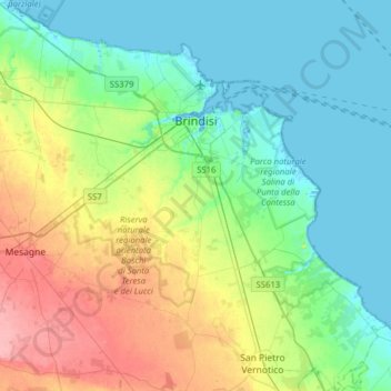
Naam: Topografische kaart Brindisi, hoogte, reliëf.
Locatie: Brindisi, Apulia, 72023, Italy (40.47842 17.73166 40.70848 18.04528)
Gemiddelde hoogte: 27 m
Minimale hoogte: -3 m
Maximale hoogte: 90 m
Brindisi experiences a Mediterranean climate (Köppen: Csa). Summers are hot and dry with abundant sunshine. Summer heat indexes can be regularly over 30 °C (86 °F) and occasionally as high as 37 °C during July and August. Winters are mild with moderate rainfall. Brindisi and the mostly topographically flat Salento peninsula is subject to light winds during the majority of the year. The two main winds in Salento are the Maestral and the Scirocco. The northerly Maestral wind from the Adriatic sea is cooling, moderating summer heat and increasing winter wind chill. The southerly Scirocco wind from the Sahara, brings higher temperatures and humidity to Salento. During spring and autumn, Sirocco winds can bring thunderstorms, occasionally dropping red sand from the Sahara in the region. Snow is rare in Brindisi but occurred during the January 2017 cold spell which brought snow and ice to much of southern Italy.
Andere topografische kaarten
Klik op een kaart om zijn topografie, zijn hoogte en zijn reliëf te bekijken.
Ceglie Messapica
Italy > Apulia > Brindisi > Ceglie Messapica
Ceglie Messapica, Brindisi, Apulia, 72013, Italy
Gemiddelde hoogte: 244 m
Francavilla Fontana
Italy > Apulia > Brindisi > Francavilla Fontana
Francavilla Fontana, Brindisi, Apulia, 72021, Italy
Gemiddelde hoogte: 138 m