
Topografische kaart La Huardière
Interactieve kaart
Klik op de kaart om de hoogte weer te geven.
Over deze kaart
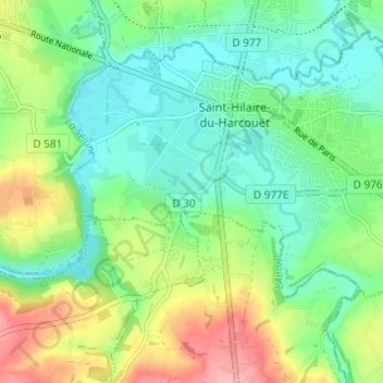
Naam: Topografische kaart La Huardière, hoogte, reliëf.
Gemiddelde hoogte: 95 m
Minimale hoogte: 57 m
Maximale hoogte: 170 m
Andere topografische kaarten
Klik op een kaart om zijn topografie, zijn hoogte en zijn reliëf te bekijken.
Saint-Hilaire-du-Harcouët
France > Normandie > Manche > Saint-Hilaire-du-Harcouët
Saint-Hilaire-du-Harcouët, Avranches, Manche, Normandie, France métropolitaine, 50600, France
Gemiddelde hoogte: 92 m
La Petite Mazure
France > Normandie > Manche > Saint-Hilaire-du-Harcouët
La Petite Mazure, Saint-Hilaire-du-Harcouët, Avranches, Manche, Normandie, France métropolitaine, 50600, France
Gemiddelde hoogte: 90 m
Saint-Martin-de-Landelles
France > Normandie > Manche > Saint-Hilaire-du-Harcouët
Saint-Martin-de-Landelles, Saint-Hilaire-du-Harcouët, Avranches, Manche, Normandie, France métropolitaine, 50730, France
Gemiddelde hoogte: 129 m