Geolokaliseren

Topografische kaart Honey Harbour

Interactieve kaart

Klik op de kaart om de hoogte weer te geven.

Over deze kaart

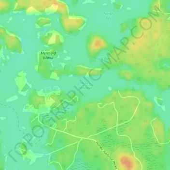
Naam: Topografische kaart Honey Harbour, hoogte, reliëf.

Locatie: Honey Harbour, Georgian Bay Township, District Municipality of Muskoka, Muskoka District, Central Ontario, Ontario, P0E 1E0, Canada (44.87391 -79.81165 44.87401 -79.81155)

Gemiddelde hoogte: 183 m

Minimale hoogte: 169 m

Maximale hoogte: 201 m

Andere topografische kaarten

Klik op een kaart om zijn topografie, zijn hoogte en zijn reliëf te bekijken.

Llanberris Island

Canada > Ontario > Muskoka District > Georgian Bay Township

Llanberris Island, Georgian Bay Township, District Municipality of Muskoka, Muskoka District, Central Ontario, Ontario, Canada

Gemiddelde hoogte: 187 m

Go Home Lake

Canada > Ontario > Muskoka District > Georgian Bay Township

Go Home Lake, Georgian Bay Township, District Municipality of Muskoka, Muskoka District, Central Ontario, Ontario, Canada

Gemiddelde hoogte: 192 m

Rose Island

Canada > Ontario > Muskoka District > Georgian Bay Township

Rose Island, Georgian Bay Township, District Municipality of Muskoka, Muskoka District, Central Ontario, Ontario, Canada

Gemiddelde hoogte: 180 m