
Topografische kaart Moatsville
Interactieve kaart
Klik op de kaart om de hoogte weer te geven.
Over deze kaart
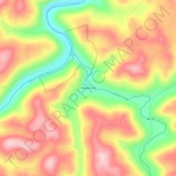
Naam: Topografische kaart Moatsville, hoogte, reliëf.
Gemiddelde hoogte: 476 m
Minimale hoogte: 338 m
Maximale hoogte: 583 m
Andere topografische kaarten
Klik op een kaart om zijn topografie, zijn hoogte en zijn reliëf te bekijken.
Volga
United States > West Virginia > Barbour County
Volga, Barbour County, West Virginia, 26238, United States
Gemiddelde hoogte: 460 m
Galloway
United States > West Virginia > Barbour County
Galloway, Barbour County, West Virginia, 26349, United States
Gemiddelde hoogte: 403 m
Century Junction
United States > West Virginia > Barbour County
Century Junction, Barbour County, West Virginia, 26238, United States
Gemiddelde hoogte: 456 m
Union
United States > West Virginia > Barbour County
Union, Barbour County, West Virginia, United States
Gemiddelde hoogte: 545 m
Belington
United States > West Virginia > Barbour County
Belington, Barbour County, West Virginia, 26250, United States
Gemiddelde hoogte: 542 m
Independence
United States > West Virginia > Barbour County > Independence
Independence, Barbour County, West Virginia, 26416, United States
Gemiddelde hoogte: 501 m
Junior
United States > West Virginia > Barbour County
Junior, Barbour County, West Virginia, 26275, United States
Gemiddelde hoogte: 587 m
Philippi
United States > West Virginia > Barbour County
Philippi, Barbour County, West Virginia, 26416, United States
Gemiddelde hoogte: 490 m