
Topografische kaart Clinton
Interactieve kaart
Klik op de kaart om de hoogte weer te geven.
Over deze kaart
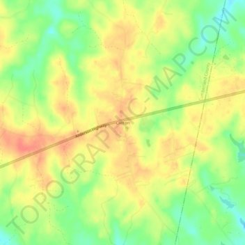
Naam: Topografische kaart Clinton, hoogte, reliëf.
Locatie: Clinton, Cumberland County, Virginia, United States (37.52265 -78.14555 37.56265 -78.10555)
Gemiddelde hoogte: 104 m
Minimale hoogte: 76 m
Maximale hoogte: 124 m
Andere topografische kaarten
Klik op een kaart om zijn topografie, zijn hoogte en zijn reliëf te bekijken.
Cotton Town
United States > Virginia > Cumberland County
Cotton Town, Cumberland County, Virginia, United States
Gemiddelde hoogte: 127 m
Stoddert
United States > Virginia > Cumberland County
Stoddert, Cumberland County, Virginia, United States
Gemiddelde hoogte: 113 m
Sunny Side
United States > Virginia > Cumberland County
Sunny Side, Cumberland County, Virginia, United States
Gemiddelde hoogte: 103 m
Hatcher
United States > Virginia > Cumberland County
Hatcher, Cumberland County, Virginia, United States
Gemiddelde hoogte: 99 m
Whiteville
United States > Virginia > Cumberland County
Whiteville, Cumberland County, Virginia, United States
Gemiddelde hoogte: 106 m
Raines Tavern
United States > Virginia > Cumberland County
Raines Tavern, Cumberland County, Virginia, United States
Gemiddelde hoogte: 136 m
Angola
United States > Virginia > Cumberland County
Angola, Cumberland County, Virginia, United States
Gemiddelde hoogte: 106 m
Hamilton
United States > Virginia > Cumberland County
Hamilton, Cumberland County, Virginia, 23027, United States
Gemiddelde hoogte: 90 m
Kimberly Hills
United States > Virginia > Cumberland County
Kimberly Hills, Cumberland County, Virginia, 23901, United States
Gemiddelde hoogte: 117 m
Hillcrest
United States > Virginia > Cumberland County
Hillcrest, Cumberland County, Virginia, 23040, United States
Gemiddelde hoogte: 130 m
Hawk
United States > Virginia > Cumberland County
Hawk, Cumberland County, Virginia, United States
Gemiddelde hoogte: 131 m
McRae
United States > Virginia > Cumberland County
McRae, Cumberland County, Virginia, United States
Gemiddelde hoogte: 134 m
Lakeside Village
United States > Virginia > Cumberland County
Lakeside Village, Cumberland County, Virginia, United States
Gemiddelde hoogte: 80 m
Trents Mill
United States > Virginia > Cumberland County
Trents Mill, Cumberland County, Virginia, United States
Gemiddelde hoogte: 94 m
Cartersville
United States > Virginia > Cumberland County
Cartersville, Cumberland County, Virginia, 23027, United States
Gemiddelde hoogte: 79 m
Guinea Mills
United States > Virginia > Cumberland County
Guinea Mills, Cumberland County, Virginia, United States
Gemiddelde hoogte: 125 m
Oak Forest
United States > Virginia > Cumberland County
Oak Forest, Cumberland County, Virginia, United States
Gemiddelde hoogte: 122 m
Ashby
United States > Virginia > Cumberland County
Ashby, Cumberland County, Virginia, United States
Gemiddelde hoogte: 111 m
Tamworth
United States > Virginia > Cumberland County
Tamworth, Cumberland County, Virginia, 23027, United States
Gemiddelde hoogte: 81 m
Trenton Mills
United States > Virginia > Cumberland County
Trenton Mills, Cumberland County, Virginia, United States
Gemiddelde hoogte: 88 m
Reeds
United States > Virginia > Cumberland County
Reeds, Cumberland County, Virginia, 23901, United States
Gemiddelde hoogte: 117 m
Cumberland
United States > Virginia > Cumberland County
Cumberland, Cumberland County, Virginia, 23040, United States
Gemiddelde hoogte: 127 m