
Doe een donatie
Rust jezelf uit voor je volgende avontuur:
Als Amazon-partner verdient deze site een commissie op in aanmerking komende aankopen, zonder extra kosten voor jou.
Topografische kaart Mangart Saddle
Klik op de kaart om de hoogte weer te geven.
Doe een donatie
Rust jezelf uit voor je volgende avontuur:
Als Amazon-partner verdient deze site een commissie op in aanmerking komende aankopen, zonder extra kosten voor jou.
Mangart Saddle
Mangart Saddle or the Mangart Pass (Slovene: Mangartsko sedlo or Mangrtsko sedlo) is a mountain saddle in the Julian Alps in northwestern Slovenia. It has an elevation of 2,072 metres (6,798 ft). It is the most common starting point for the ascent of Mt. Mangart (2,679 m or 8,789 ft). The Mangart Road (Mangartska cesta) that leads over Mangart Saddle, with its elevation of 2,055 m (6,742 ft), has a number of turns and is the highest-lying road in Slovenia. It was built in 1938. The Mangart Pass offers a picturesque view towards the Log Koritnica Valley in Slovenia to the south and the Lakes of Fusine in Italy to the north. The Mangart Saddle Lodge (koča na Mangrtskem sedlu) lies under the saddle. The saddle was the scenery of the film Let's Go Our Own Way. Mangart Saddle is also known as the finding place of manganese nodules from the Early Jurassic period.
Doe een donatie
Rust jezelf uit voor je volgende avontuur:
Als Amazon-partner verdient deze site een commissie op in aanmerking komende aankopen, zonder extra kosten voor jou.
Over deze kaart
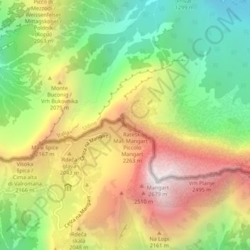
Naam: Topografische kaart Mangart Saddle, hoogte, reliëf.
Gemiddelde hoogte: 1.780 m
Minimale hoogte: 1.022 m
Maximale hoogte: 2.663 m
Doe een donatie
Rust jezelf uit voor je volgende avontuur:
Als Amazon-partner verdient deze site een commissie op in aanmerking komende aankopen, zonder extra kosten voor jou.