
Doe een donatie
Rust jezelf uit voor je volgende avontuur:
Als Amazon-partner verdient deze site een commissie op in aanmerking komende aankopen, zonder extra kosten voor jou.
Topografische kaart Hell-Bourg
Klik op de kaart om de hoogte weer te geven.
Doe een donatie
Rust jezelf uit voor je volgende avontuur:
Als Amazon-partner verdient deze site een commissie op in aanmerking komende aankopen, zonder extra kosten voor jou.
Over deze kaart
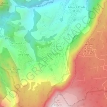
Naam: Topografische kaart Hell-Bourg, hoogte, reliëf.
Locatie: Hell-Bourg, Salazie, Saint-Benoît, Réunion, 97433, France (-21.08420 55.50226 -21.04420 55.54226)
Gemiddelde hoogte: 1.132 m
Minimale hoogte: 538 m
Maximale hoogte: 1.905 m
Doe een donatie
Rust jezelf uit voor je volgende avontuur:
Als Amazon-partner verdient deze site een commissie op in aanmerking komende aankopen, zonder extra kosten voor jou.
Andere topografische kaarten
Klik op een kaart om zijn topografie, zijn hoogte en zijn reliëf te bekijken.
Lil La Réunion
Already at the time of the India Route or Route des Indes, Réunion was a French possession located between Cape Town and the Indian trading posts, although far from the Mozambique Channel. Isle Bourbon (its name under the Ancien Régime) was not, however, the preferred position for trade and military.…
Gemiddelde hoogte: 532 m
Le Tampon
Le Tampon has an humid subtropical climate (Köppen climate classification: Cwa) at lower elevations and an oceanic climate (Köppen climate classification: Cfb) in Plains des Cafres. The average annual temperature in Le Tampon is 13.8 °C (56.8 °F). The average annual rainfall is 2,020.2 mm (79.54 in) with…
Gemiddelde hoogte: 1.005 m
La Réunion
Already at the time of the India Route or Route des Indes, Réunion was a French possession located between Cape Town and the Indian trading posts, although far from the Mozambique Channel. Isle Bourbon (its name under the Ancien Régime) was not, however, the preferred position for trade and military.…
Gemiddelde hoogte: 532 m
Doe een donatie
Rust jezelf uit voor je volgende avontuur:
Als Amazon-partner verdient deze site een commissie op in aanmerking komende aankopen, zonder extra kosten voor jou.
Doe een donatie
Rust jezelf uit voor je volgende avontuur:
Als Amazon-partner verdient deze site een commissie op in aanmerking komende aankopen, zonder extra kosten voor jou.
Sainte-Rose
Sainte-Rose features a tropical rainforest climate (Köppen Af), with substantial rainfall throughout the course of the year. Its location on the eastern side of Réunion, (windward relative to the trade winds), makes it one of the wettest cities in the world, along with Cherrapunji, Quibdó, and López de…
Gemiddelde hoogte: 505 m
Saint-Denis
The city is located on the north end of the island, and was a port. Saint-Denis was "originally the main port of Réunion, but an artificial harbour at Le Port, on the northwest coast, replaced it in the 1880s, because of unpredictable winds and tides at Saint-Denis." The city includes some of the island's…
Gemiddelde hoogte: 722 m
Réunion
Already at the time of the India Route or Route des Indes, Réunion was a French possession located between Cape Town and the Indian trading posts, although far from the Mozambique Channel. Île de Bourbon (its name under the Ancien Régime) was not, however, the preferred position for trade and military.…
Gemiddelde hoogte: 532 m
Doe een donatie
Rust jezelf uit voor je volgende avontuur:
Als Amazon-partner verdient deze site een commissie op in aanmerking komende aankopen, zonder extra kosten voor jou.
Le Tampon
Le Tampon has an humid subtropical climate (Köppen climate classification: Cwa) at lower elevations and an oceanic climate (Köppen climate classification: Cfb) in Plains des Cafres. The average annual temperature in Le Tampon is 13.8 °C (56.8 °F). The average annual rainfall is 2,020.2 mm (79.54 in) with…
Gemiddelde hoogte: 1.005 m