
Topografische kaart Kloten
Interactieve kaart
Klik op de kaart om de hoogte weer te geven.
Over deze kaart
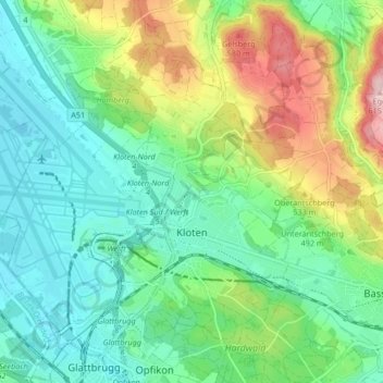
Naam: Topografische kaart Kloten, hoogte, reliëf.
Locatie: Kloten, Bezirk Bülach, Zurich, 8302, Switzerland (47.43581 8.54520 47.48131 8.62879)
Gemiddelde hoogte: 478 m
Minimale hoogte: 415 m
Maximale hoogte: 618 m
Kloten has an oceanic climate (Köppen Cfb), with sizeable continental influences due to its relative elevation and distance to any large bodies of water. Precipitation is high year-round and as a result of the cold winter nights, snowfall is frequent in winter. Due to the mild afternoons, this snow seldom sticks around for long periods of time. Summers are warm with frequent convective rainfall. The skies are generally gloomy, with a slight reversal of the trend during summer.
Andere topografische kaarten
Klik op een kaart om zijn topografie, zijn hoogte en zijn reliëf te bekijken.
Wallisellen
Switzerland > Zurich > Bezirk Bülach
Wallisellen, Bezirk Bülach, Zurich, Switzerland
Gemiddelde hoogte: 451 m
Glattfelden
Switzerland > Zurich > Bezirk Bülach
Glattfelden, Bezirk Bülach, Zurich, 8192, Switzerland
Gemiddelde hoogte: 413 m
Rorbas
Switzerland > Zurich > Bezirk Bülach > Rorbas
Rorbas, Bezirk Bülach, Zurich, 8427, Switzerland
Gemiddelde hoogte: 471 m
Nussbaumen
Switzerland > Zurich > Bezirk Bülach > Bülach > Nussbaumen
Nussbaumen, Bülach, Bezirk Bülach, Zurich, 8180, Switzerland
Gemiddelde hoogte: 453 m
Glattbrugg
Switzerland > Zurich > Bezirk Bülach
Glattbrugg, Opfikon, Bezirk Bülach, Zurich, 8152, Switzerland
Gemiddelde hoogte: 459 m