
Topografische kaart Grand Rapids
Interactieve kaart
Klik op de kaart om de hoogte weer te geven.
Over deze kaart
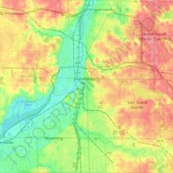
Naam: Topografische kaart Grand Rapids, hoogte, reliëf.
Locatie: Grand Rapids, Kent County, Michigan, United States (42.88365 -85.75153 43.02905 -85.56865)
Gemiddelde hoogte: 216 m
Minimale hoogte: 178 m
Maximale hoogte: 257 m
Grand Rapids developed on the banks of the Grand River, where there was once a set of rapids, at an altitude of 610 feet (186 m) above sea level. Ships could navigate on the river up to this fall line, stopping because of the rapids. The river valley is flat and narrow, surrounded by steep hills and bluffs. The terrain becomes more rolling hills away from the river. The countryside surrounding the metropolitan area consists of mixed forest and farmland, with large areas of orchards to the northwest. It is approximately 25 mi (40 km) east of Lake Michigan. The state capital of Lansing lies about 70 mi (110 km) to the east-by-southeast, and Kalamazoo is about 50 mi (80 km) to the south.
Andere topografische kaarten
Klik op een kaart om zijn topografie, zijn hoogte en zijn reliëf te bekijken.
Cole Lake
United States > Michigan > Kent County > Vergennes Township
Cole Lake, Vergennes Township, Kent County, Michigan, United States
Gemiddelde hoogte: 253 m
Dean Lake
United States > Michigan > Kent County > Plainfield Charter Township
Dean Lake, Northview, Plainfield Charter Township, Kent County, Michigan, United States
Gemiddelde hoogte: 228 m
Chase Lake
United States > Michigan > Kent County > Ada Township
Chase Lake, Ada Township, Kent County, Michigan, United States
Gemiddelde hoogte: 256 m
Stoney Lake
United States > Michigan > Kent County > Lowell
Stoney Lake, Lowell, Kent County, Michigan, United States
Gemiddelde hoogte: 203 m