Geolokaliseren
👉 Easily get elevation data in JSON, GeoTIFF and KML formats using Elevation API
Bedankt voor het steunen van deze site ❤️
Doe een donatie

Rust jezelf uit voor je volgende avontuur:

Als Amazon-partner verdient deze site een commissie op in aanmerking komende aankopen, zonder extra kosten voor jou.

Topografische kaart Auroville

Klik op de kaart om de hoogte weer te geven.

👉 Easily get elevation data in JSON, GeoTIFF and KML formats using Elevation API
Bedankt voor het steunen van deze site ❤️
Doe een donatie

Auroville

It is included in the sub-humid tropics (wet-and-dry tropical climate) situated on a plateau region with its maximum elevation of 32 m (105 ft) above sea level located in the Matrimandir area. The annual rainfall average is 1,200 mm (47 in) mainly from the SW monsoon (June to Sept.) and NE monsoon (Nov to Dec) with a dry period of approx 6 months. The average maximum temperature is 32.2 °C (90.0 °F), average minimum 20 °C (68 °F).

Wikipedia (CC-BY-SA 3.0)

Over deze kaart

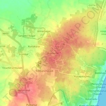
Naam: Topografische kaart Auroville, hoogte, reliëf.

Locatie: Auroville, Vanur, Viluppuram, Tamil Nadu, 605101, India (11.96739 79.76995 12.04739 79.84995)

Gemiddelde hoogte: 36 m

Minimale hoogte: 0 m

Maximale hoogte: 63 m

Andere topografische kaarten

Klik op een kaart om zijn topografie, zijn hoogte en zijn reliëf te bekijken.

Auroville

India > Tamil Nadu > Vanur > Morattandi

Gemiddelde hoogte: 47 m

Rust jezelf uit voor je volgende avontuur:

📏Afstandsmeters - Meet afstanden op kaart en terrein
🎒Wandelrugzakken - Compacte en ergonomische rugzakken voor dagtochten
📱Outdoor Smartphonehouders - Bescherm je smartphone tijdens hikes
🧣Nekwarmers & Buffs - Multifunctionele bescherming tegen wind en kou
🧥Softshell Jassen - Flexibele bescherming tegen wind en kou

Als Amazon-partner verdient deze site een commissie op in aanmerking komende aankopen, zonder extra kosten voor jou.