Topografische kaart Sihunta
Interactieve kaart
Klik op de kaart om de hoogte weer te geven.
Over deze kaart
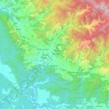
Naam: Topografische kaart Sihunta, hoogte, reliëf.
Locatie: Sihunta, Chamba district, Himachal Pradesh, India (32.22324 75.98743 32.42170 76.22230)
Gemiddelde hoogte: 1.343 m
Minimale hoogte: 507 m
Maximale hoogte: 3.598 m
Andere topografische kaarten
Klik op een kaart om zijn topografie, zijn hoogte en zijn reliëf te bekijken.
Sarahan
India > Himachal Pradesh > Sarahan
Sarahan, Kullu, Himachal Pradesh, India
Gemiddelde hoogte: 2.519 m
Shimla
India > Himachal Pradesh > Shimla (urban)
Shimla, Shimla (urban), Shimla District, Himachal Pradesh, 171001, India
Gemiddelde hoogte: 1.557 m
Lahul and Spiti
Lahul and Spiti, Himachal Pradesh, India
Gemiddelde hoogte: 4.276 m
Great Himalayan National Park
Great Himalayan National Park, Kullu, Himachal Pradesh, India
Gemiddelde hoogte: 4.303 m
Kullu
India > Himachal Pradesh > Kullu
Kullu, Himachal Pradesh, 175100, India
Gemiddelde hoogte: 1.808 m
Pin Valley National Park
Pin Valley National Park, Lahul and Spiti, Himachal Pradesh, India
Gemiddelde hoogte: 4.903 m
Sarchu
India > Himachal Pradesh > Sarchu
Sarchu, Lahul and Spiti, Himachal Pradesh, India
Gemiddelde hoogte: 4.508 m
Rohru
India > Himachal Pradesh > Rohru
Rohru, Shimla, Himachal Pradesh, 171207, India
Gemiddelde hoogte: 1.968 m