
Topografische kaart Columbia River
Interactieve kaart
Klik op de kaart om de hoogte weer te geven.
Over deze kaart
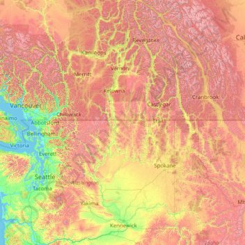
Naam: Topografische kaart Columbia River, hoogte, reliëf.
Gemiddelde hoogte: 1.102 m
Minimale hoogte: -2 m
Maximale hoogte: 4.151 m
The Columbia's heavy flow and large elevation drop over a short distance, 2.16 feet per mile (40.9 cm/km), give it tremendous capacity for hydroelectricity generation. In comparison, the Mississippi drops less than 0.65 feet per mile (12.3 cm/km). The Columbia alone possesses one-third of the United States's hydroelectric potential. In 2012, the river and its tributaries accounted for 29 GW of hydroelectric generating capacity, contributing 44 percent of the total hydroelectric generation in the nation.
Andere topografische kaarten
Klik op een kaart om zijn topografie, zijn hoogte en zijn reliëf te bekijken.
Ashnola River
United States of America > Washington > Okanogan County
Ashnola River, Okanogan County, Washington, United States of America
Gemiddelde hoogte: 2.019 m
Silver Star Mountain
United States of America > Washington > Okanogan County
Silver Star Mountain, Okanogan County, Washington, United States of America
Gemiddelde hoogte: 2.161 m