
Topografische kaart Tijuana
Interactieve kaart
Klik op de kaart om de hoogte weer te geven.
Over deze kaart
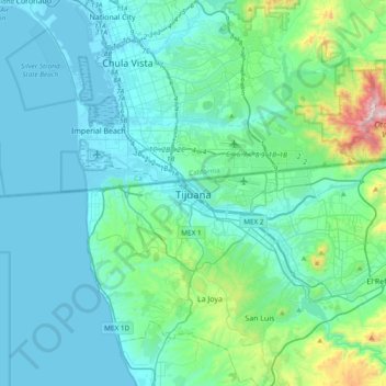
Naam: Topografische kaart Tijuana, hoogte, reliëf.
Gemiddelde hoogte: 203 m
Minimale hoogte: -2 m
Maximale hoogte: 1.069 m
Housing development in the Tijuana Hills has led to eradication of many seasonal mountain streams. This lack of natural drainage makes places within the city vulnerable to landslides during the rainy season. The varied terrain of Tijuana gives the city elevation extremes that range from sea level to 790 metres (2,590 ft).