
Topografische kaart Atlantic Coastal Plain
Interactieve kaart
Klik op de kaart om de hoogte weer te geven.
Over deze kaart
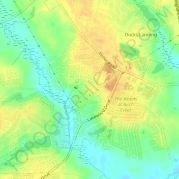
Naam: Topografische kaart Atlantic Coastal Plain, hoogte, reliëf.
Gemiddelde hoogte: 51 m
Minimale hoogte: 34 m
Maximale hoogte: 66 m
The province's average elevation is less than 900 meters above sea level and extends some 50 to 100 kilometers inland from the ocean. The coastal plain is normally wet, including many rivers, marsh, and swampland. It is composed primarily of sedimentary rock and unlithified sediments and is primarily used for agriculture. The Atlantic Coastal Plain includes the Carolina Sandhills region as well as the Embayed and Sea Island physiographic provinces. The Atlantic Coastal Plain is sometimes subdivided into northern and southern regions, specifically the Mid-Atlantic and South Atlantic coastal plains.
Andere topografische kaarten
Klik op een kaart om zijn topografie, zijn hoogte en zijn reliëf te bekijken.
Rivercliff
United States > North Carolina > Cumberland County > Fayetteville
Rivercliff, Fayetteville, Cumberland County, North Carolina, 28301, United States
Gemiddelde hoogte: 42 m
Bordeaux
United States > North Carolina > Cumberland County > Fayetteville
Bordeaux, Fayetteville, Cumberland County, North Carolina, 28248, United States
Gemiddelde hoogte: 59 m
Fenix
United States > North Carolina > Cumberland County > Fayetteville
Fenix, Fayetteville, Cumberland County, North Carolina, 28314, United States
Gemiddelde hoogte: 62 m
Cade Hill
United States > North Carolina > Cumberland County > Fayetteville
Cade Hill, Fayetteville, Cumberland County, North Carolina, United States
Gemiddelde hoogte: 26 m
Blounts Creek
United States > North Carolina > Cumberland County > Fayetteville
Blounts Creek, Fayetteville, Cumberland County, North Carolina, 28301, United States
Gemiddelde hoogte: 29 m
Owens
United States > North Carolina > Cumberland County > Fayetteville > Owens
Owens, Fayetteville, Cumberland County, North Carolina, 28305, United States
Gemiddelde hoogte: 61 m