
Topografische kaart Talamet
Interactieve kaart
Klik op de kaart om de hoogte weer te geven.
Over deze kaart
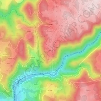
Naam: Topografische kaart Talamet, hoogte, reliëf.
Gemiddelde hoogte: 401 m
Minimale hoogte: 159 m
Maximale hoogte: 571 m
Andere topografische kaarten
Klik op een kaart om zijn topografie, zijn hoogte en zijn reliëf te bekijken.
Saint-Mathurin Léobazel
France > Nouvelle-Aquitaine > Corrèze > Camps-Saint-Mathurin-Léobazel > Saint-Mathurin Léobazel
Saint-Mathurin Léobazel, Camps-Saint-Mathurin-Léobazel, Tulle, Corrèze, Nouvelle-Aquitaine, France métropolitaine, 19430, France
Gemiddelde hoogte: 542 m
Camps
France > Nouvelle-Aquitaine > Corrèze > Camps-Saint-Mathurin-Léobazel > Camps
Camps, Camps-Saint-Mathurin-Léobazel, Tulle, Corrèze, Nouvelle-Aquitaine, France métropolitaine, 19430, France
Gemiddelde hoogte: 505 m
Vidal
France > Nouvelle-Aquitaine > Corrèze > Camps-Saint-Mathurin-Léobazel > Camps
Vidal, Camps, Camps-Saint-Mathurin-Léobazel, Tulle, Corrèze, Nouvelle-Aquitaine, France métropolitaine, 19430, France
Gemiddelde hoogte: 508 m
Le Ventoux
France > Nouvelle-Aquitaine > Corrèze > Camps-Saint-Mathurin-Léobazel
Le Ventoux, Camps-Saint-Mathurin-Léobazel, Tulle, Corrèze, Nouvelle-Aquitaine, France métropolitaine, 19430, France
Gemiddelde hoogte: 549 m