
Topografische kaart El Khroub District
Interactieve kaart
Klik op de kaart om de hoogte weer te geven.
Over deze kaart
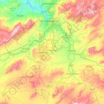
Naam: Topografische kaart El Khroub District, hoogte, reliëf.
Locatie: El Khroub District, Constantine, Algeria (36.09257 6.40589 36.41680 6.85954)
Gemiddelde hoogte: 774 m
Minimale hoogte: 302 m
Maximale hoogte: 1.339 m
Andere topografische kaarten
Klik op een kaart om zijn topografie, zijn hoogte en zijn reliëf te bekijken.
Hamma Bouziane
Algeria > Constantine > Hamma Bouziane District
Hamma Bouziane, Hamma Bouziane District, Constantine, Algeria
Gemiddelde hoogte: 572 m
El Khroub
Algeria > Constantine > El Khroub District
El Khroub, El Khroub District, Constantine, Algeria
Gemiddelde hoogte: 769 m
Belle Vue
Algeria > Constantine > Constantine > Belle Vue
Belle Vue, Constantine, Constantine District, Constantine, 25017, Algeria
Gemiddelde hoogte: 544 m
Constantine
Algeria > Constantine > Constantine District
Constantine, Constantine District, Constantine, Algeria
Gemiddelde hoogte: 656 m
Constantine
Algeria > Constantine > Constantine
Constantine, Constantine District, Constantine, 25000, Algeria
Gemiddelde hoogte: 675 m
Ali Mendjeli
Algeria > Constantine > El Khroub District
Ali Mendjeli, El Khroub, El Khroub District, Constantine, 25005, Algeria
Gemiddelde hoogte: 747 m