
Topografische kaart Potenza
Interactieve kaart
Klik op de kaart om de hoogte weer te geven.
Over deze kaart
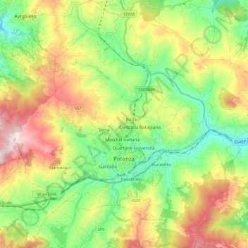
Naam: Topografische kaart Potenza, hoogte, reliëf.
Locatie: Potenza, Basilicata, Italy (40.58025 15.70628 40.74174 15.90302)
Gemiddelde hoogte: 872 m
Minimale hoogte: 574 m
Maximale hoogte: 1.347 m
The first settlement of Potentia (Potenza's original Latin name) was probably located at a lower elevation than at present, some 10 kilometres (6 miles) south of today's Potenza. The Lucani of Potentia sided against Rome's enemies during the latter's wars against the Samnites and the Bruttii. Subjugated during the 4th century BC (later gaining the status of municipium), the Potentini rebelled after the Roman defeat at Cannae in 216 BC. However, the Battle of the Metaurus marked the end of any Carthaginian aspirations in Italy and Potentia was reconquered by the Romans and reduced to the status of military colony.
Andere topografische kaarten
Klik op een kaart om zijn topografie, zijn hoogte en zijn reliëf te bekijken.
Castelsaraceno
Italy > Basilicata > Potenza
Castelsaraceno, Potenza, Basilicata, Italy
Gemiddelde hoogte: 1.104 m
Viadotto Pantanelle
Italy > Basilicata > Potenza > Nemoli
Viadotto Pantanelle, Nemoli, Potenza, Basilicata, Italy
Gemiddelde hoogte: 1.685 m
Porco Morto
Italy > Basilicata > Potenza > Picerno > Porco Morto
Porco Morto, Picerno, Potenza, Basilicata, Italy
Gemiddelde hoogte: 1.071 m
Balvano
Italy > Basilicata > Potenza > Balvano
Balvano, Potenza, Basilicata, Italy
Gemiddelde hoogte: 621 m