
Doe een donatie
Rust jezelf uit voor je volgende avontuur:
Als Amazon-partner verdient deze site een commissie op in aanmerking komende aankopen, zonder extra kosten voor jou.
Topografische kaart Pizzo Coca
Klik op de kaart om de hoogte weer te geven.
Doe een donatie
Rust jezelf uit voor je volgende avontuur:
Als Amazon-partner verdient deze site een commissie op in aanmerking komende aankopen, zonder extra kosten voor jou.
Pizzo Coca
The Alps are split into five climate zones, each with a different kind of environment. The climate, plant life and animal life vary on different sections or zones of the mountain such as Pizzo Coca. The initial altitude at Val Seriana, one of the recommended southern access points, is 1,100 meters and part of a valley. The valley trail rises to 1,892 meters by Rifugio Coca which is a rest stop.
Doe een donatie
Rust jezelf uit voor je volgende avontuur:
Als Amazon-partner verdient deze site een commissie op in aanmerking komende aankopen, zonder extra kosten voor jou.
Over deze kaart
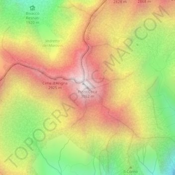
Naam: Topografische kaart Pizzo Coca, hoogte, reliëf.
Locatie: Pizzo Coca, Valbondione, Bergamo, Lombardy, Italy (46.07147 10.01149 46.07157 10.01159)
Gemiddelde hoogte: 2.380 m
Minimale hoogte: 1.652 m
Maximale hoogte: 3.042 m
Doe een donatie
Rust jezelf uit voor je volgende avontuur:
Als Amazon-partner verdient deze site een commissie op in aanmerking komende aankopen, zonder extra kosten voor jou.