
Topografische kaart Greenville County
Interactieve kaart
Klik op de kaart om de hoogte weer te geven.
Over deze kaart
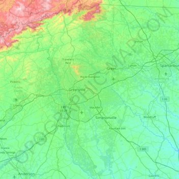
Naam: Topografische kaart Greenville County, hoogte, reliëf.
Locatie: Greenville County, South Carolina, United States of America (34.48406 -82.76441 35.21549 -82.14696)
Gemiddelde hoogte: 308 m
Minimale hoogte: 135 m
Maximale hoogte: 1.130 m
Andere topografische kaarten
Klik op een kaart om zijn topografie, zijn hoogte en zijn reliëf te bekijken.
Newberry County
United States of America > South Carolina
Newberry County, South Carolina, United States of America
Gemiddelde hoogte: 136 m
Travelers Rest
United States of America > South Carolina > Travelers Rest
Travelers Rest, Greenville County, South Carolina, United States of America
Gemiddelde hoogte: 338 m
Georgetown County
United States of America > South Carolina
Georgetown County, South Carolina, United States of America
Gemiddelde hoogte: 6 m
Charleston County
United States of America > South Carolina
Charleston County, South Carolina, United States of America
Gemiddelde hoogte: 5 m