
Topografische kaart Cole Harbour
Interactieve kaart
Klik op de kaart om de hoogte weer te geven.
Over deze kaart
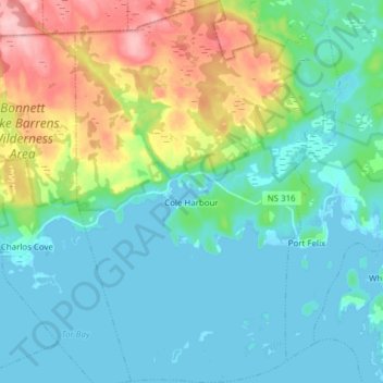
Naam: Topografische kaart Cole Harbour, hoogte, reliëf.
Gemiddelde hoogte: 39 m
Minimale hoogte: -2 m
Maximale hoogte: 156 m
Andere topografische kaarten
Klik op een kaart om zijn topografie, zijn hoogte en zijn reliëf te bekijken.
Western Island
Canada > Nova Scotia > Guysborough District Municipality > Cole Harbour
Western Island, Cole Harbour, Guysborough District Municipality, Guysborough County, Nova Scotia, Canada
Gemiddelde hoogte: 26 m
Manchester
Canada > Nova Scotia > Guysborough District Municipality
Manchester, Guysborough District Municipality, Guysborough County, Nova Scotia, Canada
Gemiddelde hoogte: 100 m
Boylston
Canada > Nova Scotia > Guysborough District Municipality
Boylston, Guysborough District Municipality, Guysborough County, Nova Scotia, B0H 1G0, Canada
Gemiddelde hoogte: 76 m