
Doe een donatie
Rust jezelf uit voor je volgende avontuur:
Als Amazon-partner verdient deze site een commissie op in aanmerking komende aankopen, zonder extra kosten voor jou.
Topografische kaart Saint Paul
Klik op de kaart om de hoogte weer te geven.
Doe een donatie
Rust jezelf uit voor je volgende avontuur:
Als Amazon-partner verdient deze site een commissie op in aanmerking komende aankopen, zonder extra kosten voor jou.
Saint Paul
The year 1858 saw more than 1,000 steamboats service Saint Paul, making it a gateway for settlers to the Minnesota frontier or Dakota Territory. Geography was a primary reason the city became a transportation hub. The location was the last good point to land riverboats coming upriver due to the river valley's topography. For a time, Saint Paul was called "The Last City of the East." Fort Snelling was important to St. Paul from the start. Direct access from St. Paul did not happen until the 7th bridge was built in 1880. Before that, there was a cable ferry crossing dating to at latest the 1840s. Once streetcars appeared, a new bridge to St. Paul was built in 1904. Until the town built its first jail the fort's brig served St. Paul.
Doe een donatie
Rust jezelf uit voor je volgende avontuur:
Als Amazon-partner verdient deze site een commissie op in aanmerking komende aankopen, zonder extra kosten voor jou.
Over deze kaart
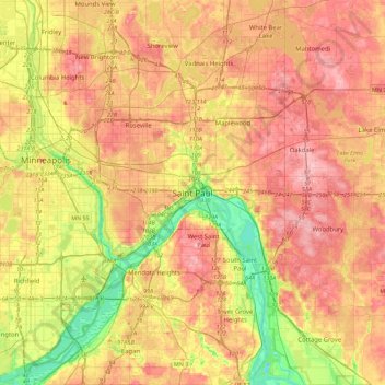
Naam: Topografische kaart Saint Paul, hoogte, reliëf.
Locatie: Saint Paul, Ramsey County, Minnesota, 55101, United States (44.78975 -93.25310 45.10975 -92.93310)
Gemiddelde hoogte: 273 m
Minimale hoogte: 199 m
Maximale hoogte: 335 m
Doe een donatie
Rust jezelf uit voor je volgende avontuur:
Als Amazon-partner verdient deze site een commissie op in aanmerking komende aankopen, zonder extra kosten voor jou.
Andere topografische kaarten
Klik op een kaart om zijn topografie, zijn hoogte en zijn reliëf te bekijken.
South Saint Anthony Park
United States > Minnesota > Ramsey County > Saint Paul
Gemiddelde hoogte: 270 m
Doe een donatie
Rust jezelf uit voor je volgende avontuur:
Als Amazon-partner verdient deze site een commissie op in aanmerking komende aankopen, zonder extra kosten voor jou.