
Topografische kaart Waipa Stream
Interactieve kaart
Klik op de kaart om de hoogte weer te geven.
Over deze kaart
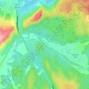
Naam: Topografische kaart Waipa Stream, hoogte, reliëf.
Gemiddelde hoogte: 343 m
Minimale hoogte: 300 m
Maximale hoogte: 424 m
Andere topografische kaarten
Klik op een kaart om zijn topografie, zijn hoogte en zijn reliëf te bekijken.
Lake Rerewhakaaitu
New Zealand > Bay of Plenty > Rotorua
Lake Rerewhakaaitu, Rotorua, Bay of Plenty, New Zealand
Gemiddelde hoogte: 440 m
Waikuta
New Zealand > Bay of Plenty > Rotorua > Ngongotaha > Waikuta
Waikuta, Ngongotaha, Rotorua, Bay of Plenty, 3015, New Zealand
Gemiddelde hoogte: 324 m
Mokoia Island
New Zealand > Bay of Plenty > Rotorua
Mokoia Island, Rotorua, Rotorua District, Bay of Plenty, New Zealand
Gemiddelde hoogte: 291 m
Kaituna River
New Zealand > Bay of Plenty > Rotorua
Kaituna River, Rotorua, Rotorua District, Bay of Plenty, New Zealand
Gemiddelde hoogte: 228 m
Mount Tarawera
New Zealand > Bay of Plenty > Rotorua
Mount Tarawera, Rotorua, Rotorua District, Bay of Plenty, New Zealand
Gemiddelde hoogte: 894 m
Tarawera River
New Zealand > Bay of Plenty > Rotorua
Tarawera River, Rotorua, Rotorua District, Bay of Plenty, New Zealand
Gemiddelde hoogte: 194 m
Lake Rotongata
New Zealand > Bay of Plenty > Rotorua
Lake Rotongata, Kaharoa Road, Rotorua, Rotorua District, Bay of Plenty, 3096, New Zealand
Gemiddelde hoogte: 340 m
Okere Falls
New Zealand > Bay of Plenty > Rotorua
Okere Falls, Rotorua, Rotorua District, Bay of Plenty, New Zealand
Gemiddelde hoogte: 315 m
Lake Rotokawa
New Zealand > Bay of Plenty > Rotorua
Lake Rotokawa, Te Huaki Crescent, Eastgate Business Park, Hannahs Bay, Rotorua, Rotorua District, Bay of Plenty, 3042, New Zealand
Gemiddelde hoogte: 306 m