
Topografische kaart Springville
Interactieve kaart
Klik op de kaart om de hoogte weer te geven.
Over deze kaart
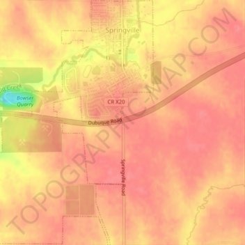
Naam: Topografische kaart Springville, hoogte, reliëf.
Locatie: Springville, Linn County, Iowa, 52336, United States (42.03459 -91.47271 42.06370 -91.43842)
Gemiddelde hoogte: 265 m
Minimale hoogte: 209 m
Maximale hoogte: 279 m
Andere topografische kaarten
Klik op een kaart om zijn topografie, zijn hoogte en zijn reliëf te bekijken.
Cedar Rapids
United States > Iowa > Linn County
Cedar Rapids, Linn County, Iowa, United States
Gemiddelde hoogte: 245 m
Bertram
United States > Iowa > Linn County
Bertram, Linn County, Iowa, United States
Gemiddelde hoogte: 232 m
Toddville
United States > Iowa > Linn County
Toddville, Linn County, Iowa, 52341, United States
Gemiddelde hoogte: 254 m
Marion
United States > Iowa > Linn County
Marion, Linn County, Iowa, 52302, United States
Gemiddelde hoogte: 256 m
Cedar Rapids
United States > Iowa > Linn County > Cedar Rapids
Cedar Rapids, Linn County, Iowa, 52401, United States
Gemiddelde hoogte: 249 m
Bertram
United States > Iowa > Linn County > Bertram > Bertram
Bertram, Linn County, Iowa, United States
Gemiddelde hoogte: 231 m
Central City
United States > Iowa > Linn County > Central City
Central City, Linn County, Iowa, 52214, United States
Gemiddelde hoogte: 269 m
Robins
United States > Iowa > Linn County > Robins
Robins, Linn County, Iowa, 52328, United States
Gemiddelde hoogte: 262 m
Palo
United States > Iowa > Linn County > Palo
Palo, Linn County, Iowa, United States
Gemiddelde hoogte: 229 m
Central City
United States > Iowa > Linn County
Central City, Linn County, Iowa, United States
Gemiddelde hoogte: 265 m
Mount Vernon
United States > Iowa > Linn County > Mount Vernon
Mount Vernon, Linn County, Iowa, 52314, United States
Gemiddelde hoogte: 254 m
Hiawatha
United States > Iowa > Linn County
Hiawatha, Linn County, Iowa, 52233, United States
Gemiddelde hoogte: 256 m