
Topografische kaart Dhamas
Interactieve kaart
Klik op de kaart om de hoogte weer te geven.
Over deze kaart
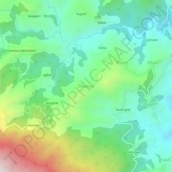
Naam: Topografische kaart Dhamas, hoogte, reliëf.
Locatie: Dhamas, Almora, Uttarakhand, 263601, India (29.58266 79.56634 29.62266 79.60634)
Gemiddelde hoogte: 1.387 m
Minimale hoogte: 1.140 m
Maximale hoogte: 1.968 m
Andere topografische kaarten
Klik op een kaart om zijn topografie, zijn hoogte en zijn reliëf te bekijken.
Binsar
India > Uttarakhand > Almora > Aayarpani
Binsar, Aayarpani, Almora, Almora District, Uttarakhand, India
Gemiddelde hoogte: 1.629 m
balsa
India > Uttarakhand > Almora > Khunt
balsa, Khunt, Almora, Almora District, Uttarakhand, 263601, India
Gemiddelde hoogte: 1.339 m
batgal
India > Uttarakhand > Almora > Almora
batgal, Almora, Almora District, Uttarakhand, 263600, India
Gemiddelde hoogte: 1.534 m
Shitlakhet
India > Uttarakhand > Almora
Shitlakhet, Almora, Almora District, Uttarakhand, 263678, India
Gemiddelde hoogte: 1.723 m
shrinagar
India > Uttarakhand > Almora
shrinagar, Almora, Almora District, Uttarakhand, 263652, India
Gemiddelde hoogte: 1.646 m
Hawālbāgh
India > Uttarakhand > Almora
Hawālbāgh, Almora, Almora District, Uttarakhand, 263643, India
Gemiddelde hoogte: 1.283 m
Binsar
India > Uttarakhand > Almora > Almora
Binsar, Almora, Uttarakhand, 263600, India
Gemiddelde hoogte: 1.954 m