
Topografische kaart Valencia
Interactieve kaart
Klik op de kaart om de hoogte weer te geven.
Over deze kaart
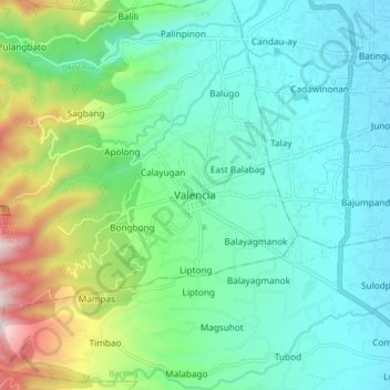
Naam: Topografische kaart Valencia, hoogte, reliëf.
Locatie: Valencia, Negros Oriental, Central Visayas, 6215, Philippines (9.24178 123.20468 9.32178 123.28468)
Gemiddelde hoogte: 250 m
Minimale hoogte: 24 m
Maximale hoogte: 966 m
Valencia occupies an area of 14,749 hectares (36,450 acres), 35% of which are classified as plains. The town is 65% mountainous, with elevation averaging from 200 to 500 metres (660 to 1,640 ft) above sea level, with the top of Mount Talinis at an elevation of 1,903 metres (6,243 ft) along the municipal southern boundary. The climate in the municipality is relatively cool, especially at higher elevations.
Andere topografische kaarten
Klik op een kaart om zijn topografie, zijn hoogte en zijn reliëf te bekijken.
West Balabag
Philippines > Negros Oriental > Valencia
West Balabag, Valencia, Negros Oriental, Central Visayas, Philippines
Gemiddelde hoogte: 195 m
Bangalon Fountain
Philippines > Negros Oriental > Valencia > Jawa
Bangalon Fountain, South Poblacion, Jawa, Valencia, Negros Oriental, Central Visayas, 6215, Philippines
Gemiddelde hoogte: 202 m
Malabo
Philippines > Negros Oriental > Valencia
Malabo, Valencia, Negros Oriental, Central Visayas, 6215, Philippines
Gemiddelde hoogte: 556 m