
Topografische kaart Fort Payne
Interactieve kaart
Klik op de kaart om de hoogte weer te geven.
Over deze kaart
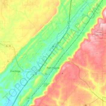
Naam: Topografische kaart Fort Payne, hoogte, reliëf.
Locatie: Fort Payne, DeKalb County, Alabama, 35967, United States (34.37007 -85.78068 34.53943 -85.60399)
Gemiddelde hoogte: 369 m
Minimale hoogte: 220 m
Maximale hoogte: 556 m
Andere topografische kaarten
Klik op een kaart om zijn topografie, zijn hoogte en zijn reliëf te bekijken.
Henagar
United States > Alabama > DeKalb County
Henagar, DeKalb County, Alabama, 35978, United States
Gemiddelde hoogte: 436 m
Mentone
United States > Alabama > DeKalb County
Mentone, DeKalb County, Alabama, 35984, United States
Gemiddelde hoogte: 471 m
Grove Oak
United States > Alabama > DeKalb County
Grove Oak, DeKalb County, Alabama, 35975, United States
Gemiddelde hoogte: 344 m
Hammondville
United States > Alabama > DeKalb County
Hammondville, DeKalb County, Alabama, United States
Gemiddelde hoogte: 362 m
Shiloh
United States > Alabama > DeKalb County
Shiloh, DeKalb County, Alabama, United States
Gemiddelde hoogte: 376 m
Lakeview
United States > Alabama > DeKalb County
Lakeview, DeKalb County, Alabama, United States
Gemiddelde hoogte: 344 m
Valley Head
United States > Alabama > DeKalb County
Valley Head, DeKalb County, Alabama, United States
Gemiddelde hoogte: 410 m
Collinsville
United States > Alabama > DeKalb County
Collinsville, DeKalb County, Alabama, 35961, United States
Gemiddelde hoogte: 285 m
Rainsville
United States > Alabama > DeKalb County
Rainsville, DeKalb County, Alabama, 35986, United States
Gemiddelde hoogte: 380 m
Crossville
United States > Alabama > DeKalb County
Crossville, DeKalb County, Alabama, United States
Gemiddelde hoogte: 337 m
Powell
United States > Alabama > DeKalb County
Powell, DeKalb County, Alabama, United States
Gemiddelde hoogte: 380 m
Mentone
United States > Alabama > DeKalb County
Mentone, DeKalb County, Alabama, 35984, United States
Gemiddelde hoogte: 470 m
Geraldine
United States > Alabama > DeKalb County
Geraldine, DeKalb County, Alabama, 35974, United States
Gemiddelde hoogte: 349 m
Fyffe
United States > Alabama > DeKalb County
Fyffe, DeKalb County, Alabama, 35971, United States
Gemiddelde hoogte: 376 m
Pine Ridge
United States > Alabama > DeKalb County
Pine Ridge, DeKalb County, Alabama, United States
Gemiddelde hoogte: 312 m
Desoto State Park
United States > Alabama > DeKalb County > Fort Payne
Desoto State Park, Fort Payne, DeKalb County, Alabama, United States
Gemiddelde hoogte: 454 m
Minvale
United States > Alabama > DeKalb County > Fort Payne > Minvale
Minvale, Fort Payne, DeKalb County, Alabama, 35967, United States
Gemiddelde hoogte: 322 m
Little River Canyon National Preserve
United States > Alabama > DeKalb County > Fort Payne
Little River Canyon National Preserve, Fort Payne, DeKalb County, Alabama, United States
Gemiddelde hoogte: 328 m
Collinsville
United States > Alabama > DeKalb County > Collinsville
Collinsville, DeKalb County, Alabama, 35961, United States
Gemiddelde hoogte: 285 m
Fort Payne
United States > Alabama > DeKalb County > Fort Payne
Fort Payne, DeKalb County, Alabama, 35967, United States
Gemiddelde hoogte: 350 m
Ider
United States > Alabama > DeKalb County
Ider, DeKalb County, Alabama, United States
Gemiddelde hoogte: 467 m
Red Hill
United States > Alabama > DeKalb County
Red Hill, DeKalb County, Alabama, United States
Gemiddelde hoogte: 255 m
Sylvania
United States > Alabama > DeKalb County
Sylvania, DeKalb County, Alabama, 35988, United States
Gemiddelde hoogte: 405 m