
Topografische kaart Sahand
Interactieve kaart
Klik op de kaart om de hoogte weer te geven.
Sahand
Sahand is one of the highest mountains in Iranian Azerbaijan, in addition to being an important dormant volcano in the country. The Sahand mountains are directly south of Tabriz, the highest peak of which is Kamal at an elevation of 3,707 m (12,162 ft). Approximately 17 peaks can be accounted for as being over 3,000 m (9,843 ft) in height. Due to the presence of a variety of flora and fauna, the Sahand mountains are known as the bride of mountains in Iran.
Over deze kaart
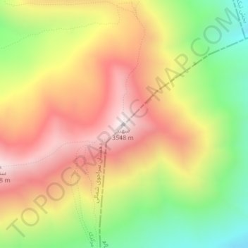
Naam: Topografische kaart Sahand, hoogte, reliëf.
Gemiddelde hoogte: 3.118 m
Minimale hoogte: 2.651 m
Maximale hoogte: 3.542 m