
Topografische kaart Chailey
Klik op de kaart om de hoogte weer te geven.
Over deze kaart
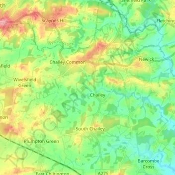
Naam: Topografische kaart Chailey, hoogte, reliëf.
Locatie: Chailey, Lewes, East Sussex, England, United Kingdom (50.91919 -0.06415 51.00252 0.01819)
Gemiddelde hoogte: 40 m
Minimale hoogte: 7 m
Maximale hoogte: 97 m
Andere topografische kaarten
Klik op een kaart om zijn topografie, zijn hoogte en zijn reliëf te bekijken.
Ditchling Beacon
United Kingdom > England > East Sussex > Lewes
Ditchling Beacon is the highest point in East Sussex, England, with an elevation of 248 m (814 ft). It is south of Ditchling and to the north-east of Brighton. It is a large chalk hill with a particularly steep northern face, covered with open grassland and sheep-grazing areas. It is the third-highest point on…
Gemiddelde hoogte: 144 m
Kingston Near Lewes
United Kingdom > England > East Sussex > Lewes > Kingston Near Lewes
Gemiddelde hoogte: 65 m
South Heighton
United Kingdom > England > East Sussex > Lewes > South Heighton
Gemiddelde hoogte: 37 m