
Topografische kaart Addison
Interactieve kaart
Klik op de kaart om de hoogte weer te geven.
Over deze kaart
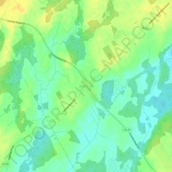
Naam: Topografische kaart Addison, hoogte, reliëf.
Gemiddelde hoogte: 119 m
Minimale hoogte: 107 m
Maximale hoogte: 133 m
Andere topografische kaarten
Klik op een kaart om zijn topografie, zijn hoogte en zijn reliëf te bekijken.
Harvey Island
Canada > Ontario > Leeds and Grenville Counties > Elizabethtown-Kitley
Harvey Island, Elizabethtown-Kitley, Leeds and Grenville Counties, Eastern Ontario, Ontario, K6V 5T7, Canada
Gemiddelde hoogte: 111 m
Motts Mills
Canada > Ontario > Leeds and Grenville Counties > Elizabethtown-Kitley
Motts Mills, Elizabethtown-Kitley, Leeds and Grenville Counties, Eastern Ontario, Ontario, K0G 1L0, Canada
Gemiddelde hoogte: 126 m
Greenbush
Canada > Ontario > Leeds and Grenville Counties > Elizabethtown-Kitley > Greenbush
Greenbush, Elizabethtown-Kitley, Leeds and Grenville Counties, Eastern Ontario, Ontario, K0E 1A0, Canada
Gemiddelde hoogte: 120 m
Toledo
Canada > Ontario > Leeds and Grenville Counties > Elizabethtown-Kitley
Toledo, Elizabethtown-Kitley, Leeds and Grenville Counties, Eastern Ontario, Ontario, K0E 1Y0, Canada
Gemiddelde hoogte: 121 m
Lyn
Canada > Ontario > Leeds and Grenville Counties > Elizabethtown-Kitley
Lyn, Elizabethtown-Kitley, Leeds and Grenville Counties, Eastern Ontario, Ontario, K0E 1M0, Canada
Gemiddelde hoogte: 102 m