
Topografische kaart Warners Bay
Interactieve kaart
Klik op de kaart om de hoogte weer te geven.
Over deze kaart
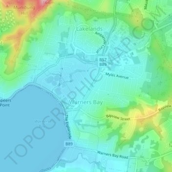
Naam: Topografische kaart Warners Bay, hoogte, reliëf.
Gemiddelde hoogte: 32 m
Minimale hoogte: -2 m
Maximale hoogte: 149 m
Andere topografische kaarten
Klik op een kaart om zijn topografie, zijn hoogte en zijn reliëf te bekijken.
King Edward Park
Australia > New South Wales > Newcastle
King Edward Park, Newcastle, Newcastle-Maitland, Newcastle City Council, New South Wales, 2300, Australia
Gemiddelde hoogte: 8 m
Kotara
Australia > New South Wales > Newcastle
Kotara, Newcastle, Newcastle-Maitland, Newcastle City Council, New South Wales, 2289, Australia
Gemiddelde hoogte: 68 m
Newcastle
Australia > New South Wales > Newcastle
Newcastle, Newcastle-Maitland, Newcastle City Council, New South Wales, 2300, Australia
Gemiddelde hoogte: 5 m
Newcastle
Australia > New South Wales > Newcastle
Belmont, Newcastle, Newcastle-Maitland, Lake Macquarie City Council, New South Wales, 2280, Australia
Gemiddelde hoogte: 14 m
Lambton
Australia > New South Wales > Newcastle
Lambton, Newcastle, Newcastle-Maitland, Newcastle City Council, New South Wales, 2299, Australia
Gemiddelde hoogte: 37 m
Speers Point
Australia > New South Wales > Newcastle
Speers Point, Newcastle, Newcastle-Maitland, Lake Macquarie City Council, New South Wales, 2284, Australia
Gemiddelde hoogte: 27 m
Killingworth
Australia > New South Wales > Newcastle
Killingworth, Newcastle, Newcastle-Maitland, Lake Macquarie City Council, New South Wales, 2278, Australia
Gemiddelde hoogte: 60 m