
Topografische kaart Blue Ridge Parkway
Interactieve kaart
Klik op de kaart om de hoogte weer te geven.
Over deze kaart
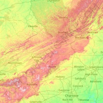
Naam: Topografische kaart Blue Ridge Parkway, hoogte, reliëf.
Gemiddelde hoogte: 505 m
Minimale hoogte: 56 m
Maximale hoogte: 1.958 m
The parkway has been the most visited unit of the National Park System every year since 1946 except four (1949, 2013, 2016 and 2019).[4][5] Land on either side of the road is owned and maintained by the National Park Service, and in many places parkway land is bordered by United States Forest Service property. There is no fee for using the parkway; however, commercial vehicles are prohibited without approval from the Park Service Headquarters, near Asheville, North Carolina.[6][7] The roadway is not maintained in the winter, and sections that pass over especially high elevations and through tunnels are often impassable and therefore closed from late fall through early spring. Weather is extremely variable in the mountains, so conditions and closures often change rapidly. The speed limit is never higher than 45 mph (72 km/h) and is lower in some sections.
Andere topografische kaarten
Klik op een kaart om zijn topografie, zijn hoogte en zijn reliëf te bekijken.
Boone
United States > North Carolina > Watauga County
Boone, Watauga County, North Carolina, United States
Gemiddelde hoogte: 1.068 m
Meat Camp
United States > North Carolina > Watauga County
Meat Camp, Watauga County, North Carolina, United States
Gemiddelde hoogte: 1.166 m
Foscoe
United States > North Carolina > Watauga County
Foscoe, Watauga County, North Carolina, United States
Gemiddelde hoogte: 998 m
Sugar Grove
United States > North Carolina > Watauga County
Sugar Grove, Watauga County, North Carolina, 28692, United States
Gemiddelde hoogte: 895 m
Moses H Cone Memorial Park
United States > North Carolina > Watauga County > Blowing Rock
Moses H Cone Memorial Park, Blowing Rock, Watauga County, North Carolina, 28605, United States
Gemiddelde hoogte: 1.121 m
Seven Devils
United States > North Carolina > Watauga County
Seven Devils, Watauga County, North Carolina, United States
Gemiddelde hoogte: 1.175 m
Triplett
United States > North Carolina > Watauga County
Triplett, Watauga County, North Carolina, 28618, United States
Gemiddelde hoogte: 718 m
Zionville
United States > North Carolina > Watauga County > Zionville
Zionville, Watauga County, North Carolina, 27691, United States
Gemiddelde hoogte: 1.060 m
Vilas
United States > North Carolina > Watauga County
Vilas, Watauga County, North Carolina, 28692, United States
Gemiddelde hoogte: 898 m
Moretz
United States > North Carolina > Watauga County > Moretz
Moretz, Watauga County, North Carolina, United States
Gemiddelde hoogte: 989 m
Boone
United States > North Carolina > Watauga County > Boone > Boone
Boone, Watauga County, North Carolina, 28607-1017, United States
Gemiddelde hoogte: 977 m
Sorrento Skies
United States > North Carolina > Watauga County > Sorrento Skies
Sorrento Skies, Watauga County, North Carolina, 28607-1000, United States
Gemiddelde hoogte: 1.069 m
Blowing Rock
United States > North Carolina > Watauga County
Blowing Rock, Watauga County, North Carolina, 28605, United States
Gemiddelde hoogte: 1.032 m
Kelsey
United States > North Carolina > Watauga County > Kelsey
Kelsey, Watauga County, North Carolina, 28605, United States
Gemiddelde hoogte: 978 m
Rominger
United States > North Carolina > Watauga County > Rominger
Rominger, Watauga County, North Carolina, 28679, United States
Gemiddelde hoogte: 1.068 m
Beech Mountain
United States > North Carolina > Watauga County > Beech Mountain
Beech Mountain, Watauga County, North Carolina, United States
Gemiddelde hoogte: 1.264 m
Beech Mountain
United States > North Carolina > Watauga County
Beech Mountain, Watauga County, North Carolina, United States
Gemiddelde hoogte: 1.267 m