Geolokaliseren

Topografische kaart Aylmer

Interactieve kaart

Klik op de kaart om de hoogte weer te geven.

Over deze kaart

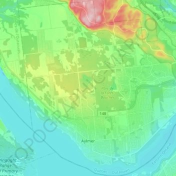
Naam: Topografische kaart Aylmer, hoogte, reliëf.

Locatie: Aylmer, Gatineau, Gatineau (ville), Outaouais, Quebec, Canada (45.37238 -75.90835 45.48568 -75.75587)

Gemiddelde hoogte: 99 m

Minimale hoogte: 46 m

Maximale hoogte: 260 m

Andere topografische kaarten

Klik op een kaart om zijn topografie, zijn hoogte en zijn reliëf te bekijken.

Hull

Canada > Quebec > Gatineau

Hull, Gatineau, Outaouais, Quebec, Canada

Gemiddelde hoogte: 69 m

Gatineau

Canada > Quebec > Gatineau

Gatineau, Outaouais, Quebec, Canada

Gemiddelde hoogte: 107 m