
Topografische kaart Lower Garden District
Interactieve kaart
Klik op de kaart om de hoogte weer te geven.
Over deze kaart
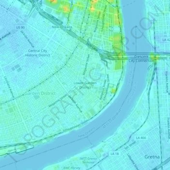
Naam: Topografische kaart Lower Garden District, hoogte, reliëf.
Gemiddelde hoogte: 3 m
Minimale hoogte: -6 m
Maximale hoogte: 27 m
Lower Garden District is located at 29°56′02″N 90°04′12″W / 29.93389°N 90.07000°W / 29.93389; -90.07000 and has an elevation of 6 feet (1.8 m). According to the United States Census Bureau, the district has a total area of 1.16 square miles (3.0 km2), 0.95 square miles (2.5 km2) of which is land and 0.21 square miles (0.5 km2) (18.1%) of which is water.