
Topografische kaart Doña Ana County
Interactieve kaart
Klik op de kaart om de hoogte weer te geven.
Over deze kaart
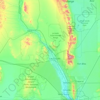
Naam: Topografische kaart Doña Ana County, hoogte, reliëf.
Locatie: Doña Ana County, New Mexico, United States of America (31.78351 -107.29971 33.05281 -106.34051)
Gemiddelde hoogte: 1.349 m
Minimale hoogte: 1.137 m
Maximale hoogte: 2.696 m
Andere topografische kaarten
Klik op een kaart om zijn topografie, zijn hoogte en zijn reliëf te bekijken.
Bernalillo County
United States of America > New Mexico
Bernalillo County, New Mexico, United States of America
Gemiddelde hoogte: 1.808 m
Santa Fe County
United States of America > New Mexico
Santa Fe County, New Mexico, United States of America
Gemiddelde hoogte: 2.177 m
Taos County
United States of America > New Mexico
Taos County, New Mexico, United States of America
Gemiddelde hoogte: 2.561 m