

Topografische kaart Jolarpet
Klik op de kaart om de hoogte weer te geven.
Jolarpet
Jolarpet is a second grade municipality in Tirupattur district. Jolarpet is renowned for its railway station. The town is also located on State Highway 18 connecting Vaniyambadi -Tirupattur. Regarding transportation linkage, the highway (NH 48) from Chennai to Krishnagiri passes through the outskirts of the town. Jolarpettai municipality comprises four revenue villages, namely, Vakkanampatti, Ediyampatti Ossinattam Vattam, Kudiyana Kuppam, and spreads over an area of 13.06 km2. Location of Yelagiri hills close with the town supports growth of the town to a greater extent. Almost the whole of Jolarpet Municipality consists of flat terrain. The general slope is towards southeast and the small streams that rise in the Yelagiri hills situated in the west eventually fall into the Palar river. The topography of Jolarpet in plain and it is situated at an altitude of 186.75 meters above mean sea level. The wind direction is predominant towards southwest for the whole of the year However, during summer it is from southwest to northeast.
Over deze kaart
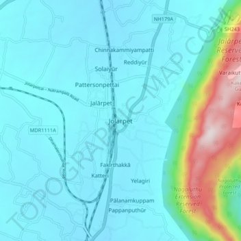
Naam: Topografische kaart Jolarpet, hoogte, reliëf.
Locatie: Jolarpet, Tirupathur, Tirupattur, Tamil Nadu, 635851, India (12.52432 78.53972 12.60432 78.61972)
Gemiddelde hoogte: 493 m
Minimale hoogte: 383 m
Maximale hoogte: 1.117 m