
Topografische kaart Bushman's River
Interactieve kaart
Klik op de kaart om de hoogte weer te geven.
Over deze kaart
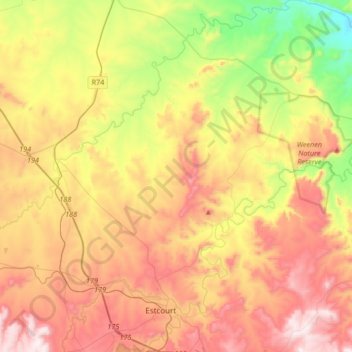
Naam: Topografische kaart Bushman's River, hoogte, reliëf.
Gemiddelde hoogte: 1.089 m
Minimale hoogte: 702 m
Maximale hoogte: 1.496 m
Andere topografische kaarten
Klik op een kaart om zijn topografie, zijn hoogte en zijn reliëf te bekijken.
Umtshezi Ward 8
RSA > KwaZulu-Natal > Umtshezi Local Municipality
Umtshezi Ward 8, Umtshezi Local Municipality, Uthukela District Municipality, KwaZulu-Natal, RSA
Gemiddelde hoogte: 1.037 m