
Topografische kaart Spearfish
Interactieve kaart
Klik op de kaart om de hoogte weer te geven.
Over deze kaart
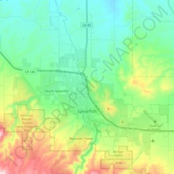
Naam: Topografische kaart Spearfish, hoogte, reliëf.
Locatie: Spearfish, Lawrence County, South Dakota, United States (44.45282 -103.90541 44.56661 -103.71413)
Gemiddelde hoogte: 1.171 m
Minimale hoogte: 984 m
Maximale hoogte: 1.643 m
Extreme winter maxima in the district are remarkably warm given the latitude and altitude; on January 19, 1921 Spearfish reached a temperature of 79 °F (26 °C), the hottest January temperature in South Dakota on record.
Andere topografische kaarten
Klik op een kaart om zijn topografie, zijn hoogte en zijn reliëf te bekijken.
Savoy
United States > South Dakota > Lawrence County
Savoy, Lawrence County, South Dakota, United States
Gemiddelde hoogte: 1.665 m
Deadwood
United States > South Dakota > Lawrence County
Deadwood, Lawrence County, South Dakota, 57732, United States
Gemiddelde hoogte: 1.511 m
Terry Peak
United States > South Dakota > Lawrence County
Terry Peak, Lawrence County, South Dakota, United States
Gemiddelde hoogte: 1.940 m
Cheyenne Crossing
United States > South Dakota > Lawrence County
Cheyenne Crossing, Lawrence County, South Dakota, United States
Gemiddelde hoogte: 1.784 m
Bridal Veil Falls
United States > South Dakota > Lawrence County
Bridal Veil Falls, Lawrence County, South Dakota, United States
Gemiddelde hoogte: 1.502 m
Spearfish
United States > South Dakota > Lawrence County > Spearfish
Spearfish, Lawrence County, South Dakota, 57783, United States
Gemiddelde hoogte: 1.291 m
Lead
United States > South Dakota > Lawrence County
Lead, Lawrence County, South Dakota, United States
Gemiddelde hoogte: 1.605 m