
Topografische kaart Bot River
Interactieve kaart
Klik op de kaart om de hoogte weer te geven.
Over deze kaart
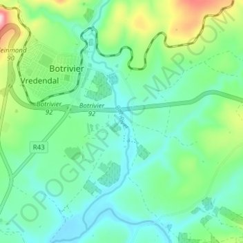
Naam: Topografische kaart Bot River, hoogte, reliëf.
Gemiddelde hoogte: 85 m
Minimale hoogte: 12 m
Maximale hoogte: 301 m
Andere topografische kaarten
Klik op een kaart om zijn topografie, zijn hoogte en zijn reliëf te bekijken.
Theewaterskloof Ward 12
RSA > Western Cape > Theewaterskloof Local Municipality
Theewaterskloof Ward 12, Theewaterskloof Local Municipality, Overberg District Municipality, Western Cape, RSA
Gemiddelde hoogte: 384 m
Groenlandberg Nature Reserve
RSA > Western Cape > Theewaterskloof Local Municipality
Groenlandberg Nature Reserve, Groenlandberg MTB Trail, Theewaterskloof Ward 9, Theewaterskloof Local Municipality, Overberg District Municipality, Western Cape, RSA
Gemiddelde hoogte: 518 m
Klein River
RSA > Western Cape > Theewaterskloof Local Municipality
Klein River, Theewaterskloof Local Municipality, Overberg District Municipality, Western Cape, RSA
Gemiddelde hoogte: 191 m
Lebanon Nature Reserve
RSA > Western Cape > Theewaterskloof Local Municipality
Lebanon Nature Reserve, N2, Theewaterskloof Ward 7, Theewaterskloof Local Municipality, Overberg District Municipality, Western Cape, 7160, RSA
Gemiddelde hoogte: 307 m
Greyton Nature Reserve
RSA > Western Cape > Theewaterskloof Local Municipality
Greyton Nature Reserve, Boesmankloof Hiking Trail, Theewaterskloof Ward 2, Theewaterskloof Local Municipality, Overberg District Municipality, Western Cape, RSA
Gemiddelde hoogte: 674 m
Vrolijkheid Nature Reserve
RSA > Western Cape > Theewaterskloof Local Municipality
Vrolijkheid Nature Reserve, Theewaterskloof Ward 1, Theewaterskloof Local Municipality, Overberg District Municipality, Western Cape, RSA
Gemiddelde hoogte: 406 m
Caledon Nature Reserve
RSA > Western Cape > Theewaterskloof Local Municipality
Caledon Nature Reserve, Cape Epic, Theewaterskloof Ward 4, Theewaterskloof Local Municipality, Overberg District Municipality, Western Cape, 7230, RSA
Gemiddelde hoogte: 389 m