
Topografische kaart Damariscotta
Interactieve kaart
Klik op de kaart om de hoogte weer te geven.
Over deze kaart
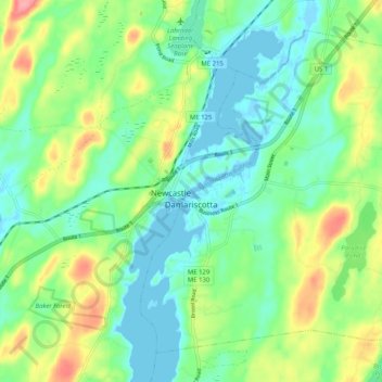
Naam: Topografische kaart Damariscotta, hoogte, reliëf.
Locatie: Damariscotta, Lincoln County, Maine, 04543, United States (44.00432 -69.54519 44.06615 -69.44345)
Gemiddelde hoogte: 29 m
Minimale hoogte: -4 m
Maximale hoogte: 88 m
According to the United States Census Bureau, the town has a total area of 14.71 square miles (38.10 km2), of which, 12.42 square miles (32.17 km2) of it is land and 2.29 square miles (5.93 km2) is water. Damariscotta is situated on the Damariscotta River, a tidal estuary of the Gulf of Maine. Hunt Hill, elevation 350 feet (108 m) above sea level, is the town's highest point.
Andere topografische kaarten
Klik op een kaart om zijn topografie, zijn hoogte en zijn reliëf te bekijken.
Westport Island
United States > Maine > Lincoln County > Westport Island
Westport Island, Lincoln County, Maine, United States
Gemiddelde hoogte: 21 m
Davis Island
United States > Maine > Lincoln County > Edgecomb
Davis Island, Edgecomb, Lincoln County, Maine, United States
Gemiddelde hoogte: 13 m
Boothbay Harbor
United States > Maine > Lincoln County
Boothbay Harbor, Lincoln County, Maine, United States
Gemiddelde hoogte: 13 m
Nobleboro
United States > Maine > Lincoln County
Nobleboro, Lincoln County, Maine, 04555, United States
Gemiddelde hoogte: 40 m
East Boothbay
United States > Maine > Lincoln County > Boothbay
East Boothbay, Boothbay, Lincoln County, Maine, 04568, United States
Gemiddelde hoogte: 16 m
Dresden
United States > Maine > Lincoln County
Dresden, Lincoln County, Maine, 04342, United States
Gemiddelde hoogte: 45 m
Booth Bay
United States > Maine > Lincoln County > Southport
Booth Bay, Southport, Lincoln County, Maine, 04570, United States
Gemiddelde hoogte: 1 m
Newcastle
United States > Maine > Lincoln County
Newcastle, Lincoln County, Maine, 04553, United States
Gemiddelde hoogte: 31 m
Boothbay
United States > Maine > Lincoln County
Boothbay, Lincoln County, Maine, United States
Gemiddelde hoogte: 9 m
West Boothbay Harbor
United States > Maine > Lincoln County > Boothbay Harbor
West Boothbay Harbor, Boothbay Harbor, Lincoln County, Maine, 04575, United States
Gemiddelde hoogte: 10 m
Wiscasset
United States > Maine > Lincoln County
Wiscasset, Lincoln County, Maine, 04578, United States
Gemiddelde hoogte: 35 m
Southport
United States > Maine > Lincoln County
Southport, Lincoln County, Maine, United States
Gemiddelde hoogte: 5 m
Bristol
United States > Maine > Lincoln County
Bristol, Lincoln County, Maine, United States
Gemiddelde hoogte: 13 m
Cabbage Island
United States > Maine > Lincoln County > Boothbay
Cabbage Island, Boothbay, Lincoln County, Maine, 04538, United States
Gemiddelde hoogte: 17 m
Edgecomb
United States > Maine > Lincoln County
Edgecomb, Lincoln County, Maine, United States
Gemiddelde hoogte: 25 m
South Bristol
United States > Maine > Lincoln County
South Bristol, Lincoln County, Maine, United States
Gemiddelde hoogte: 13 m
Bremen
United States > Maine > Lincoln County
Bremen, Lincoln County, Maine, 04551, United States
Gemiddelde hoogte: 22 m
Alna
United States > Maine > Lincoln County
Alna, Lincoln County, Maine, 04535, United States
Gemiddelde hoogte: 43 m
Jefferson
United States > Maine > Lincoln County
Jefferson, Lincoln County, Maine, 04348, United States
Gemiddelde hoogte: 60 m
Whitefield
United States > Maine > Lincoln County
Whitefield, Lincoln County, Maine, 04353, United States
Gemiddelde hoogte: 60 m
Barters Island
United States > Maine > Lincoln County > Boothbay
Barters Island, Boothbay, Lincoln County, Maine, 04571, United States
Gemiddelde hoogte: 18 m
Waldoboro
United States > Maine > Lincoln County
Waldoboro, Lincoln County, Maine, 04572, United States
Gemiddelde hoogte: 40 m
New Harbor
United States > Maine > Lincoln County > Bristol
New Harbor, Bristol, Lincoln County, Maine, 04541, United States
Gemiddelde hoogte: 13 m