
Topografische kaart Shannon Municipal District
Interactieve kaart
Klik op de kaart om de hoogte weer te geven.
Over deze kaart
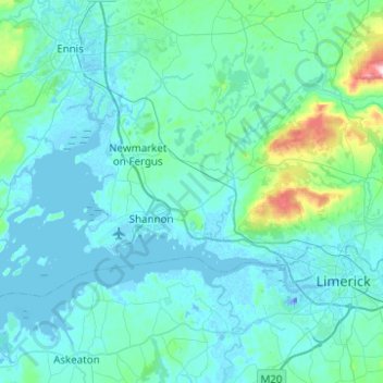
Naam: Topografische kaart Shannon Municipal District, hoogte, reliëf.
Locatie: Shannon Municipal District, County Clare, Munster, Ierland (52.66153 -8.99690 52.80161 -8.50165)
Gemiddelde hoogte: 35 m
Minimale hoogte: -26 m
Maximale hoogte: 418 m
Andere topografische kaarten
Klik op een kaart om zijn topografie, zijn hoogte en zijn reliëf te bekijken.
Shannon
Ierland > County Clare > Shannon
Shannon, Shannon Municipal District, County Clare, Munster, V14 AK19, Ierland
Gemiddelde hoogte: 10 m